
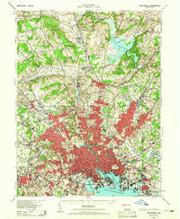
~ Baltimore MD topo map, 1:62500 scale, 15 X 15 Minute, Historical, 1943, updated 1965
Baltimore, Maryland, USGS topographic map dated 1943.
Includes geographic coordinates (latitude and longitude). This topographic map is suitable for hiking, camping, and exploring, or framing it as a wall map.
Printed on-demand using high resolution imagery, on heavy weight and acid free paper, or alternatively on a variety of synthetic materials.
Topos available on paper, Waterproof, Poly, or Tyvek. Usually shipping rolled, unless combined with other folded maps in one order.
- Product Number: USGS-5367942
- Free digital map download (high-resolution, GeoPDF): Baltimore, Maryland (file size: 11 MB)
- Map Size: please refer to the dimensions of the GeoPDF map above
- Weight (paper map): ca. 55 grams
- Map Type: POD USGS Topographic Map
- Map Series: HTMC
- Map Verison: Historical
- Cell ID: 50921
- Scan ID: 257294
- Imprint Year: 1965
- Woodland Tint: Yes
- Aerial Photo Year: 1938
- Datum: NAD27
- Map Projection: Polyconic
- Map published by United States Army Corps of Engineers
- Map published by United States Army
- Map Language: English
- Scanner Resolution: 600 dpi
- Map Cell Name: Baltimore
- Grid size: 15 X 15 Minute
- Date on map: 1943
- Map Scale: 1:62500
- Geographical region: Maryland, United States
Neighboring Maps:
All neighboring USGS topo maps are available for sale online at a variety of scales.
Spatial coverage:
Topo map Baltimore, Maryland, covers the geographical area associated the following places:
- Bosley (historical) - Pikesville - Harborview - Rockland Run - Briarwood Farms - Country Club Park - Valleywood - Cheswolde - Malvern - Jones Valley - Melvale - Haywood Heights - Fullerton - West Hills - Riverview (historical) - Blenheim Manor - West Edmondale - Lakeside - Govanstown - Pinehurst - Graceland - North Wind - Bridlewood - Martins Choice - Bluegrass Heights - Ashlar Hill - Cloverfield Manor - Williamsburg - Chestnut Hill - Brigadoon - Asylum (historical) - Cylburn (historical) - Milestone Manor - The Village - O'Donnell Heights - Hampton Village - Tufton Ridge Estates - Arlington - Stanbrook - The Lakes - Halcyon Gate - Westview Park - Saint Helena - Academy Heights - Liberty Mobile Home Park - Laureldale - The Willows of Ruxton - Devonshire Forest - Fallstaff - Belgravia - Colonial Village - Bellview - Wetheredsville - Windsor Terrace - The Terraces - Mount Vernon - Kenwood - Yorktown - Harristown - Worthington Ridge - Stoneleigh - Waverly - Rosedale Terrace - Fells Point - York Ridge - Broadway-Orleans Homes - Dulaney Hills - Valley Brook - Lutz Hill - Mays Chapel - Franklintown - Roland Park - Forest Park - Greengate - Parkville Heights - Ruxton Hills - The Colony - Beechfield - Woodward - Ridgemont - Stevenson - Towson Park - Rosedale - Kenwood - Burnbrae - Catonsville Heights - Hunting Lodge - Stratford - Ridge Grove - Highlandtown - North Wind Farms - Murray Hill - Hampton Gardens - Powhatan - Minersville (historical) - Ralston - Guilford - Powhatan Hill - Mayfair - Shetland Hills
- Map Area ID: AREA39.539.25-76.75-76.5
- Northwest corner Lat/Long code: USGSNW39.5-76.75
- Northeast corner Lat/Long code: USGSNE39.5-76.5
- Southwest corner Lat/Long code: USGSSW39.25-76.75
- Southeast corner Lat/Long code: USGSSE39.25-76.5
- Northern map edge Latitude: 39.5
- Southern map edge Latitude: 39.25
- Western map edge Longitude: -76.75
- Eastern map edge Longitude: -76.5


