
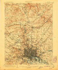
~ Baltimore MD topo map, 1:62500 scale, 15 X 15 Minute, Historical, 1904, updated 1907
Baltimore, Maryland, USGS topographic map dated 1904.
Includes geographic coordinates (latitude and longitude). This topographic map is suitable for hiking, camping, and exploring, or framing it as a wall map.
Printed on-demand using high resolution imagery, on heavy weight and acid free paper, or alternatively on a variety of synthetic materials.
Topos available on paper, Waterproof, Poly, or Tyvek. Usually shipping rolled, unless combined with other folded maps in one order.
- Product Number: USGS-5367934
- Free digital map download (high-resolution, GeoPDF): Baltimore, Maryland (file size: 11 MB)
- Map Size: please refer to the dimensions of the GeoPDF map above
- Weight (paper map): ca. 55 grams
- Map Type: POD USGS Topographic Map
- Map Series: HTMC
- Map Verison: Historical
- Cell ID: 50921
- Scan ID: 257289
- Imprint Year: 1907
- Survey Year: 1902
- Datum: Unstated
- Map Projection: Unstated
- Map published by United States Geological Survey
- Map Language: English
- Scanner Resolution: 600 dpi
- Map Cell Name: Baltimore
- Grid size: 15 X 15 Minute
- Date on map: 1904
- Map Scale: 1:62500
- Geographical region: Maryland, United States
Neighboring Maps:
All neighboring USGS topo maps are available for sale online at a variety of scales.
Spatial coverage:
Topo map Baltimore, Maryland, covers the geographical area associated the following places:
- Butchers Hill - Hall Spring - Cub Hills - Fox Ridge Estates - Burnbrae - Howardsville - Morrell Park - Wetheredsville - Govanstown - Ralston - Country Club Park - Valley North - Greene Tree - Harford Hills - Britinay Hills - Ramblewood - Springdale - Rogers (historical) - Halcyon Gate - Shawan at Hunt Valley - West Glen - Wakefield - Autumn Wind - Halifax Heights - Beaumont Park - Westport - Chattolanee - Oakleigh Manor - Windsor Mill Manor - Caves Park - Dulaney Village - Brighton - Linhigh - South Baltimore - Academy Heights - Oak Forest Park - Cedarwood Estates - West Forest Park - Lutherville - Hudson Heights - Rognel Heights - College Hills - Beverly Hills - Loch Raven Village - Chestnut Hill - Edmondson Ridge - Greenbrier - Evergreen - Denmore Park - Grey Rock - Calverton - Hamilton - Lauraville - Fells Point - Mays Chapel - Dundalk - Four Winds - Leahigh - Green Valley North - Milford - Ruxton Ridge - Towson - Woodmoor - The Terraces - Deer Run - Roslyn - Mount Winans - Lakeland - Glenmont - Long Meadow West - Daybreak Estates - Eudowood - Claremont (historical) - Padonia - Glenmore Park - Greenspring - Stevenson - Shetland Hills - Brooklandville - The Village - Pickwick - Colonial Village - Brooks Hill - Carney - The Beechs - Malvern - Eccleston Valley - Williamsburg - Windsor Terrace - Valley View - Bare Hills - Meadowcliff - Edmondson Village - Jones Valley - Ruxton Hills - The Cloisters at Charles - Valley Heights - Stratford - Howard Park - Huntcrest Estates
- Map Area ID: AREA39.539.25-76.75-76.5
- Northwest corner Lat/Long code: USGSNW39.5-76.75
- Northeast corner Lat/Long code: USGSNE39.5-76.5
- Southwest corner Lat/Long code: USGSSW39.25-76.75
- Southeast corner Lat/Long code: USGSSE39.25-76.5
- Northern map edge Latitude: 39.5
- Southern map edge Latitude: 39.25
- Western map edge Longitude: -76.75
- Eastern map edge Longitude: -76.5


