
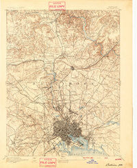
~ Baltimore MD topo map, 1:62500 scale, 15 X 15 Minute, Historical, 1894, updated 1894
Baltimore, Maryland, USGS topographic map dated 1894.
Includes geographic coordinates (latitude and longitude). This topographic map is suitable for hiking, camping, and exploring, or framing it as a wall map.
Printed on-demand using high resolution imagery, on heavy weight and acid free paper, or alternatively on a variety of synthetic materials.
Topos available on paper, Waterproof, Poly, or Tyvek. Usually shipping rolled, unless combined with other folded maps in one order.
- Product Number: USGS-5367924
- Free digital map download (high-resolution, GeoPDF): Baltimore, Maryland (file size: 10 MB)
- Map Size: please refer to the dimensions of the GeoPDF map above
- Weight (paper map): ca. 55 grams
- Map Type: POD USGS Topographic Map
- Map Series: HTMC
- Map Verison: Historical
- Cell ID: 50921
- Scan ID: 257283
- Imprint Year: 1894
- Survey Year: 1890
- Datum: Unstated
- Map Projection: Unstated
- Map published by United States Geological Survey
- Map Language: English
- Scanner Resolution: 600 dpi
- Map Cell Name: Baltimore
- Grid size: 15 X 15 Minute
- Date on map: 1894
- Map Scale: 1:62500
- Geographical region: Maryland, United States
Neighboring Maps:
All neighboring USGS topo maps are available for sale online at a variety of scales.
Spatial coverage:
Topo map Baltimore, Maryland, covers the geographical area associated the following places:
- Caves Park - Euclid Heights - Rockland Run - Brierleigh - Wetheredsville - Cub Hill Farms - Cherry Hill - Mount Hope - Valley North - Keyser Woods - Mayfair - Laurelford - Riderwood Hills - Greenwood - Country Club Park - Loch Hill - Velvet Valley - Glenmore Park - Dulaney Valley (historical) - Carroll Manor - Fullerton - Sudbrook Park - Walbrook - Ruxton Hills - Helmsley Court - Broadmeade - Haver Hill - Cowpen - Knollcrest Manor - Pot Spring - Tufton Ridge Estates - Knollwood - Pennbrook - Timberline Park - Long Meadows Estates - Woodmoor - Canterbury Estates - Claremont (historical) - Dundalk Mobile Home Court - Sherwood Hills - Summit Park - Hillside Hunt - Worthington Greens - Powhatan - Campus Hills - Gilmor Homes - Hillendale Park - Hampton - Irvington - Stoneleigh - Town and Country North - Stab - Glenmont - Carney - Goodnow Hill - Harristown - Rogers (historical) - The Hill Farm - Pimlico - Haywood Heights - Morrell Park - Old Town - Linhigh - Colonial Park - Milford - Brookview Farms - Manor Hill - Four Winds - Howard Park - Mount DeSales - Howardsville - Harford Farms - Ramblewood - Cub Hills - Westport - Hudson Heights - Woodward - Falls Gable - Velvet Ridge - Calverton - Hillendale - Latrobe Homes - Mount Clare - Fells Point - The Terraces - Westowne - Homeland - Meadowcliff - Glenside Park - Hillbrook - Defense Heights - Chapel Ridge - Sugarvale Estates - Saint Helena - Mount Vernon - Evergreen - Chapelgate - Dixon Hill - Eastpoint - Anton North
- Map Area ID: AREA39.539.25-76.75-76.5
- Northwest corner Lat/Long code: USGSNW39.5-76.75
- Northeast corner Lat/Long code: USGSNE39.5-76.5
- Southwest corner Lat/Long code: USGSSW39.25-76.75
- Southeast corner Lat/Long code: USGSSE39.25-76.5
- Northern map edge Latitude: 39.5
- Southern map edge Latitude: 39.25
- Western map edge Longitude: -76.75
- Eastern map edge Longitude: -76.5


