
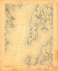
~ Annapolis MD topo map, 1:62500 scale, 15 X 15 Minute, Historical, 1892
Annapolis, Maryland, USGS topographic map dated 1892.
Includes geographic coordinates (latitude and longitude). This topographic map is suitable for hiking, camping, and exploring, or framing it as a wall map.
Printed on-demand using high resolution imagery, on heavy weight and acid free paper, or alternatively on a variety of synthetic materials.
Topos available on paper, Waterproof, Poly, or Tyvek. Usually shipping rolled, unless combined with other folded maps in one order.
- Product Number: USGS-5367910
- Free digital map download (high-resolution, GeoPDF): Annapolis, Maryland (file size: 7 MB)
- Map Size: please refer to the dimensions of the GeoPDF map above
- Weight (paper map): ca. 55 grams
- Map Type: POD USGS Topographic Map
- Map Series: HTMC
- Map Verison: Historical
- Cell ID: 50592
- Scan ID: 257270
- Survey Year: 1890
- Datum: Unstated
- Map Projection: Unstated
- Map published by United States Geological Survey
- Map Language: English
- Scanner Resolution: 600 dpi
- Map Cell Name: Annapolis
- Grid size: 15 X 15 Minute
- Date on map: 1892
- Map Scale: 1:62500
- Geographical region: Maryland, United States
Neighboring Maps:
All neighboring USGS topo maps are available for sale online at a variety of scales.
Spatial coverage:
Topo map Annapolis, Maryland, covers the geographical area associated the following places:
- Bay View Heights - Annapolis Cove - Goose Point Estates - Kitty Creek - Baie Holm - Bembe Beach - Broad Creek Farms - Shipping Creek - Crescendo - Ferry Farms - Anchorage - Mattapex - Arundel on the Bay - Beechwood on the Burley - Saunders Point - Twin Cove Estates - Sherwood - Cloverfields - Felicity Cove - Marling Farms - Bridge Point - Pendennis Mount - Grace Creek - Georgetown East - Kent Point Farm - Annapolis Roads - Providence (historical) - Kent Point Manor - Tunis - Mallard Point - Crosswinds - Wardour Bluffs - Calverton - Fishing Creek Farms - Eastport - Venice Beach - Wardour - New Point - Skipping Creek Plantation - Hillsmere Estates - Kent Timbers - Walnut Lake - Town Home Village - West Shoreham - Snug Harbor - McDaniel - Victor Haven - Shoreham Beach - Harborview - Romancoke on the Bay - Kangaroo Beach - Nutcracker Point - Craney Creek Estates - West Annapolis - Wittman - Sharktown - Sunny Isle of Kent - Bay City - Round View - Rolles Beach - Matapeake Estates - Walnut Shores - Baldwin Acres - Providence Cove - Chesterhaven Beach - Watergate Village - Highland Beach - Cox Creek Acres - Stevensville - Elktonia - Tanglewood - Lands End - Oyster Harbor - Claibornes Landing - Chrisland at Annapolis Cove - Cheslou Village - Old Annapolis Neck - Chester - Matapeake - Normans - Eastport Terrace - Valliant - Watergate - Island View - Colony Hills - Bentons Pleasure - Dominion - Annapolis - Southwind - Paradise Island - Wilshire - Brightwood - Chews Manor - Indian Harbor - Blackwalnut Cove - Keys Farm - Old Point Estates - Bloomsbury Square - Mount Pleasant - Kent Cove
- Map Area ID: AREA3938.75-76.5-76.25
- Northwest corner Lat/Long code: USGSNW39-76.5
- Northeast corner Lat/Long code: USGSNE39-76.25
- Southwest corner Lat/Long code: USGSSW38.75-76.5
- Southeast corner Lat/Long code: USGSSE38.75-76.25
- Northern map edge Latitude: 39
- Southern map edge Latitude: 38.75
- Western map edge Longitude: -76.5
- Eastern map edge Longitude: -76.25


