
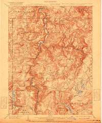
~ Accident MD topo map, 1:62500 scale, 15 X 15 Minute, Historical, 1900, updated 1918
Accident, Maryland, USGS topographic map dated 1900.
Includes geographic coordinates (latitude and longitude). This topographic map is suitable for hiking, camping, and exploring, or framing it as a wall map.
Printed on-demand using high resolution imagery, on heavy weight and acid free paper, or alternatively on a variety of synthetic materials.
Topos available on paper, Waterproof, Poly, or Tyvek. Usually shipping rolled, unless combined with other folded maps in one order.
- Product Number: USGS-5367902
- Free digital map download (high-resolution, GeoPDF): Accident, Maryland (file size: 11 MB)
- Map Size: please refer to the dimensions of the GeoPDF map above
- Weight (paper map): ca. 55 grams
- Map Type: POD USGS Topographic Map
- Map Series: HTMC
- Map Verison: Historical
- Cell ID: 50294
- Scan ID: 257266
- Imprint Year: 1918
- Survey Year: 1898
- Datum: Unstated
- Map Projection: Unstated
- Map published by United States Geological Survey
- Map Language: English
- Scanner Resolution: 600 dpi
- Map Cell Name: Accident
- Grid size: 15 X 15 Minute
- Date on map: 1900
- Map Scale: 1:62500
- Geographical region: Maryland, United States
Neighboring Maps:
All neighboring USGS topo maps are available for sale online at a variety of scales.
Spatial coverage:
Topo map Accident, Maryland, covers the geographical area associated the following places:
- Asher Glade - Friendsville - Gravel Hill - Keeler Glade - Strawn - Cranesville - Hoyes Run - Locust Grove - Mineral Spring - Hoyes - Kendall - Watsondale (historical) - Addison - McHenry - Blooming Rose - Unamis - Accident - McComas Beach - Kaese Mill - Selbysport - Markleysburg - Fiketown - Sand Spring - Thayerville - Engle Mill - Elder Hill - Lake Ford - Geices (historical)
- Map Area ID: AREA39.7539.5-79.5-79.25
- Northwest corner Lat/Long code: USGSNW39.75-79.5
- Northeast corner Lat/Long code: USGSNE39.75-79.25
- Southwest corner Lat/Long code: USGSSW39.5-79.5
- Southeast corner Lat/Long code: USGSSE39.5-79.25
- Northern map edge Latitude: 39.75
- Southern map edge Latitude: 39.5
- Western map edge Longitude: -79.5
- Eastern map edge Longitude: -79.25


