
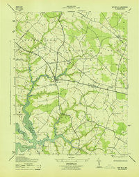
~ Wye Mills MD topo map, 1:31680 scale, 7.5 X 7.5 Minute, Historical, 1943
Wye Mills, Maryland, USGS topographic map dated 1943.
Includes geographic coordinates (latitude and longitude). This topographic map is suitable for hiking, camping, and exploring, or framing it as a wall map.
Printed on-demand using high resolution imagery, on heavy weight and acid free paper, or alternatively on a variety of synthetic materials.
Topos available on paper, Waterproof, Poly, or Tyvek. Usually shipping rolled, unless combined with other folded maps in one order.
- Product Number: USGS-5367892
- Free digital map download (high-resolution, GeoPDF): Wye Mills, Maryland (file size: 6 MB)
- Map Size: please refer to the dimensions of the GeoPDF map above
- Weight (paper map): ca. 55 grams
- Map Type: POD USGS Topographic Map
- Map Series: HTMC
- Map Verison: Historical
- Cell ID: 49953
- Scan ID: 257256
- Woodland Tint: Yes
- Datum: NAD27
- Map Projection: Polyconic
- Map published by United States Army Corps of Engineers
- Map published by United States Department of War
- Map Language: English
- Scanner Resolution: 600 dpi
- Map Cell Name: Wye Mills
- Grid size: 7.5 X 7.5 Minute
- Date on map: 1943
- Map Scale: 1:31680
- Geographical region: Maryland, United States
Neighboring Maps:
All neighboring USGS topo maps are available for sale online at a variety of scales.
Spatial coverage:
Topo map Wye Mills, Maryland, covers the geographical area associated the following places:
- Wye Mills - Bloomingdale - Dolvin - Saulsbury - Skipton - Fox Meadow - Starr - Willoughby - Newtown Square - Scottown - Mill Creek - Newtown - Queenstown Mobile Home Park - Wye Landing - Georgia Woods - Wye Heights - Yorke (historical)
- Map Area ID: AREA3938.875-76.125-76
- Northwest corner Lat/Long code: USGSNW39-76.125
- Northeast corner Lat/Long code: USGSNE39-76
- Southwest corner Lat/Long code: USGSSW38.875-76.125
- Southeast corner Lat/Long code: USGSSE38.875-76
- Northern map edge Latitude: 39
- Southern map edge Latitude: 38.875
- Western map edge Longitude: -76.125
- Eastern map edge Longitude: -76


