
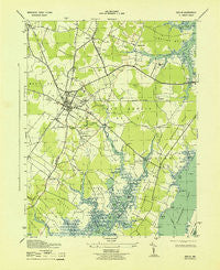
~ Berlin MD topo map, 1:31680 scale, 7.5 X 7.5 Minute, Historical, 1943
Berlin, Maryland, USGS topographic map dated 1943.
Includes geographic coordinates (latitude and longitude). This topographic map is suitable for hiking, camping, and exploring, or framing it as a wall map.
Printed on-demand using high resolution imagery, on heavy weight and acid free paper, or alternatively on a variety of synthetic materials.
Topos available on paper, Waterproof, Poly, or Tyvek. Usually shipping rolled, unless combined with other folded maps in one order.
- Product Number: USGS-5367614
- Free digital map download (high-resolution, GeoPDF): Berlin, Maryland (file size: 6 MB)
- Map Size: please refer to the dimensions of the GeoPDF map above
- Weight (paper map): ca. 55 grams
- Map Type: POD USGS Topographic Map
- Map Series: HTMC
- Map Verison: Historical
- Cell ID: 3442
- Scan ID: 257056
- Woodland Tint: Yes
- Datum: NAD27
- Map Projection: Polyconic
- Map published by United States Army Corps of Engineers
- Map published by United States Department of War
- Map Language: English
- Scanner Resolution: 600 dpi
- Map Cell Name: Berlin
- Grid size: 7.5 X 7.5 Minute
- Date on map: 1943
- Map Scale: 1:31680
- Geographical region: Maryland, United States
Neighboring Maps:
All neighboring USGS topo maps are available for sale online at a variety of scales.
Spatial coverage:
Topo map Berlin, Maryland, covers the geographical area associated the following places:
- Ironshire - Salt Grass Cove - Golf Club Shores - Lake Haven Mobile Home Park - Silver Lake Mobile Home Park - Dills Acres - Briddletown - Sherwood Forest - Friendship - Snug Harbor - Highland Park - Holly Grove - Grays Corner - Germantown - Friendship Estates - Lewis Corner - Sinepuxent - Newport Hills - Saint Martin - Morris Mobile Home Park - Taylorville - Douglynne Woods - Berlin - Hayes Landing - Franklin Heights - Wood Duck Isle - Albatross Mobile Home Park - Kitts Hill - Pomona Heights - Trappe
- Map Area ID: AREA38.37538.25-75.25-75.125
- Northwest corner Lat/Long code: USGSNW38.375-75.25
- Northeast corner Lat/Long code: USGSNE38.375-75.125
- Southwest corner Lat/Long code: USGSSW38.25-75.25
- Southeast corner Lat/Long code: USGSSE38.25-75.125
- Northern map edge Latitude: 38.375
- Southern map edge Latitude: 38.25
- Western map edge Longitude: -75.25
- Eastern map edge Longitude: -75.125


