
~ Westminster MD topo map, 1:24000 scale, 7.5 X 7.5 Minute, Historical, 1953, updated 1988
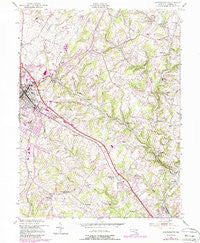
Westminster, Maryland, USGS topographic map dated 1953.
Includes geographic coordinates (latitude and longitude). This topographic map is suitable for hiking, camping, and exploring, or framing it as a wall map.
Printed on-demand using high resolution imagery, on heavy weight and acid free paper, or alternatively on a variety of synthetic materials.
Topos available on paper, Waterproof, Poly, or Tyvek. Usually shipping rolled, unless combined with other folded maps in one order.
- Product Number: USGS-5367498
- Free digital map download (high-resolution, GeoPDF): Westminster, Maryland (file size: 14 MB)
- Map Size: please refer to the dimensions of the GeoPDF map above
- Weight (paper map): ca. 55 grams
- Map Type: POD USGS Topographic Map
- Map Series: HTMC
- Map Verison: Historical
- Cell ID: 48424
- Scan ID: 256996
- Imprint Year: 1988
- Woodland Tint: Yes
- Photo Revision Year: 1979
- Aerial Photo Year: 1977
- Edit Year: 1979
- Datum: NAD27
- Map Projection: Polyconic
- Map published by United States Army Corps of Engineers
- Map Language: English
- Scanner Resolution: 600 dpi
- Map Cell Name: Westminster
- Grid size: 7.5 X 7.5 Minute
- Date on map: 1953
- Map Scale: 1:24000
- Geographical region: Maryland, United States
Neighboring Maps:
All neighboring USGS topo maps are available for sale online at a variety of scales.
Spatial coverage:
Topo map Westminster, Maryland, covers the geographical area associated the following places:
- Autumn Ridge - Bethel - Harper Estates - Middle Brooke - Hoffmans Mill - White Oak Ridge - Walnut Ridge - Duncans Hill - Smallwood Acres - Tabbys Delight - Sharon Oaks - Greenbrier - Mountain Lake View - Aspen Run - Eden Farms - Maple View - Sullivans Trailer Park - Topkapi - Evergreen Hills - Todd Village Mobile Home Park - Lees Corner - Peppermint Park - Lismarelu Farms - Sylvan Park - Scotsdale - Richwynn Hill - Alto Vista - Maple Crest - Hickory Ridge Farms - Dove Ridge - Dominos Acres - Lawndale - Sullivan Heights - Trebee Highlands - Rebas Retreat - Houcksville - Holiday Acres - Cape Horn South - Laura Lee Estates - Bollinger Estates - Grafton Manor - Pine Knoll - Patapsco - Harris Heights - Random Heights - Eastview - Carrollton - Fairfield - Mexico - Dublin Manor - Northbrook - Snydersburg - Deerpark - Brunetto Acres - Wilimot Manor - Lester Acres - Campus Heights - Sandyville - Eastview Estates - Hillsdale - Covilla - Reese - Velvet Run - Buckingham View - Finlandia - Adams Chance - Patapsco Woods - Cascade Estates - Glover Acres - Dell Mont - Lawndale Acres - Yorkland - Constance Acres - Zipprian Estates - Twin Knolls - Fenby - Kalten Acres - Shawnee View - Ben-Har Heights - Reese Manor - Bethel Ridge - Walnut Grove Mills - Snydersburg Manor - Village of Bachman - Carriage Hills - Brummel - Rebecca Ridge - Castles Rising - Beaver Ridge - Piedmont Acres - Wesley Chapel - Benedict Woods - Tannery - Smallwood - Washington Court - Village of Peachwood - Green Acres - Winterberry - Winsome Heights - Hillandale Trailer Park
- Map Area ID: AREA39.62539.5-77-76.875
- Northwest corner Lat/Long code: USGSNW39.625-77
- Northeast corner Lat/Long code: USGSNE39.625-76.875
- Southwest corner Lat/Long code: USGSSW39.5-77
- Southeast corner Lat/Long code: USGSSE39.5-76.875
- Northern map edge Latitude: 39.625
- Southern map edge Latitude: 39.5
- Western map edge Longitude: -77
- Eastern map edge Longitude: -76.875


