
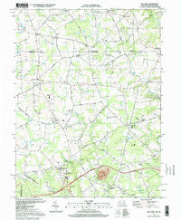
~ Bay View MD topo map, 1:24000 scale, 7.5 X 7.5 Minute, Historical, 1997, updated 1999
Bay View, Maryland, USGS topographic map dated 1997.
Includes geographic coordinates (latitude and longitude). This topographic map is suitable for hiking, camping, and exploring, or framing it as a wall map.
Printed on-demand using high resolution imagery, on heavy weight and acid free paper, or alternatively on a variety of synthetic materials.
Topos available on paper, Waterproof, Poly, or Tyvek. Usually shipping rolled, unless combined with other folded maps in one order.
- Product Number: USGS-5365730
- Free digital map download (high-resolution, GeoPDF): Bay View, Maryland (file size: 11 MB)
- Map Size: please refer to the dimensions of the GeoPDF map above
- Weight (paper map): ca. 55 grams
- Map Type: POD USGS Topographic Map
- Map Series: HTMC
- Map Verison: Historical
- Cell ID: 2722
- Scan ID: 256047
- Imprint Year: 1999
- Woodland Tint: Yes
- Photo Inspection Year: 1997
- Aerial Photo Year: 1987
- Datum: NAD27
- Map Projection: Lambert Conformal Conic
- Map published by United States Geological Survey
- Map Language: English
- Scanner Resolution: 600 dpi
- Map Cell Name: Bay View
- Grid size: 7.5 X 7.5 Minute
- Date on map: 1997
- Map Scale: 1:24000
- Geographical region: Maryland, United States
Neighboring Maps:
All neighboring USGS topo maps are available for sale online at a variety of scales.
Spatial coverage:
Topo map Bay View, Maryland, covers the geographical area associated the following places:
- Marley Village - Ewingville (historical) - Tailwinds Estates - Blue Ball Village - Zion Acres - Farmcrest - Eder - Elk Mills - Calvert Acres - Peacedale - Lum Estates - Ponds Edge - Middlecroft - Glen Hope (historical) - Westminister - The Estates of Wyn Lea - Zion - Chantilly Manor - Lombard Acres - Edgewood Hills - Leeds - Highpoint - Providence - Beulah Land - Nellys Corner (historical) - Hickory Hill - Chrome - Mechanic Valley - Stony Chase Court - Wyn Lea at Fair Hill - Pleasant Hill - Blake - Old Line Village of Fair Hill - Fair Hill Meadows - Shah Valley - Union Valley - Fairfields - Pleasant Hill Mobile Home Park - The Rock (historical) - Pawnee Lake Hills - Forest Green Court - Blueball - Lombard - Cedar Hill - Bay View - Forest Green Court - Boomdecker - Pearl Estates - Calvert - Hillview Estates
- Map Area ID: AREA39.7539.625-76-75.875
- Northwest corner Lat/Long code: USGSNW39.75-76
- Northeast corner Lat/Long code: USGSNE39.75-75.875
- Southwest corner Lat/Long code: USGSSW39.625-76
- Southeast corner Lat/Long code: USGSSE39.625-75.875
- Northern map edge Latitude: 39.75
- Southern map edge Latitude: 39.625
- Western map edge Longitude: -76
- Eastern map edge Longitude: -75.875


