
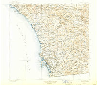
~ Southern California Sheet No 2 CA topo map, 1:250000 scale, 1 X 1 Degree, Historical, 1904, updated 1924
Southern California Sheet No 2, California, USGS topographic map dated 1904.
Includes geographic coordinates (latitude and longitude). This topographic map is suitable for hiking, camping, and exploring, or framing it as a wall map.
Printed on-demand using high resolution imagery, on heavy weight and acid free paper, or alternatively on a variety of synthetic materials.
Topos available on paper, Waterproof, Poly, or Tyvek. Usually shipping rolled, unless combined with other folded maps in one order.
- Product Number: USGS-5688572
- Free digital map download (high-resolution, GeoPDF): Southern California Sheet No 2, California (file size: 10 MB)
- Map Size: please refer to the dimensions of the GeoPDF map above
- Weight (paper map): ca. 55 grams
- Map Type: POD USGS Topographic Map
- Map Series: HTMC
- Map Verison: Historical
- Cell ID: 396038
- Scan ID: 299912
- Imprint Year: 1924
- Survey Year: 1902
- Datum: Unstated
- Map Projection: Polyconic
- Map published by United States Geological Survey
- Map Language: English
- Scanner Resolution: 600 dpi
- Map Cell Name: Southern California Sheet No. 2
- Grid size: 1 X 1 Degree
- Date on map: 1904
- Map Scale: 1:250000
- Geographical region: California, United States
Neighboring Maps:
All neighboring USGS topo maps are available for sale online at a variety of scales.
Spatial coverage:
Topo map Southern California Sheet No 2, California, covers the geographical area associated the following places:
- New Frontier Mobile Home Park - Homelands - Rainbow Canyon Village - San Marcos - Casitas del Sol Mobile Home Park - Spring Valley - Tiki Mobile Village - Three Arch Bay - Jofegan - Brooklyn Heights - Carlsbad Trailer Park - Cajon Heights - Fiesta Shores - Highlands Mobile Home Park - Palomar Park Mobile Home Park - Mission Hills - Imperial Beach - Boal - La Playa - Poway - Canyon Crest Mobile Home Park - La Mesa - Bayside Village - Laguna Junction - Whispering Pines - Oak Grove - Butterfield Lake Estates - Rancho Carlsbad Trailer Park - Julian - Blossom Valley - Mission del Magnolia Mobile Home Park - Fleetridge - El Capitan (historical) - Ocean Beach - Capistrano Valley Mobile Home Estates - Rincon - Potrero - Del Mar - Lake San Marcos - Johnstown - Ridgecrest Estates - Eagles Nest - Sunset Terrace Mobile Home Park - Alpine Heights - Laguna Vista Trailer Park - Suncrest - San Diego - Linda Vista (historical) - San Diego Country Estates - De Anza Trailer Harbor - Dehesa - Normal Heights - Casa de Oro - Santa Ysabel - Vista Verde Estates Mobile Home Park - La Presa - Rancho Vista Mobile Home Park - The Willows - Meadowbrook Mobile Home Park - Cuyamaca (historical) - La Costa - South San Diego - Shady Dell - Miramar - Oceanside - Yaldora - College Heights - Ocean Hills - Hideaway Mobile Estates - El Cajon - Barrett Junction - Aguanga - Jesmond Dene - Campland on the Bay Trailer Park - Rancho Escondido Mobile Home Park - South Bay Terraces - Pacific Beach - Olivenhain - Casa Grande Estates Mobile Home Park - Bancroft Point - Jamacha - Vista Manor Trailer Park - La Jolla Hermosa - San Juan Mobile Home Estates - Jamacha Junction - Clairemont - Country Manor Estates - Scripps Ranch - Allied Gardens - La Jolla - Indian Springs - Bellview Park Mobile Home Park - Stockton - San Ysidro - Vista Cascade Mobile Home Park - Castle Park - Palm City - Mira Mesa - Mussey Grove (historical) - Mobile Park West Mobile Home Park
- Map Area ID: AREA33.532.5-117.75-116.5
- Northwest corner Lat/Long code: USGSNW33.5-117.75
- Northeast corner Lat/Long code: USGSNE33.5-116.5
- Southwest corner Lat/Long code: USGSSW32.5-117.75
- Southeast corner Lat/Long code: USGSSE32.5-116.5
- Northern map edge Latitude: 33.5
- Southern map edge Latitude: 32.5
- Western map edge Longitude: -117.75
- Eastern map edge Longitude: -116.5


