
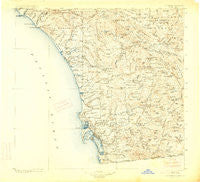
~ Southern California Sheet No 2 CA topo map, 1:250000 scale, 1 X 1 Degree, Historical, 1904, updated 1914
Southern California Sheet No 2, California, USGS topographic map dated 1904.
Includes geographic coordinates (latitude and longitude). This topographic map is suitable for hiking, camping, and exploring, or framing it as a wall map.
Printed on-demand using high resolution imagery, on heavy weight and acid free paper, or alternatively on a variety of synthetic materials.
Topos available on paper, Waterproof, Poly, or Tyvek. Usually shipping rolled, unless combined with other folded maps in one order.
- Product Number: USGS-5688570
- Free digital map download (high-resolution, GeoPDF): Southern California Sheet No 2, California (file size: 9 MB)
- Map Size: please refer to the dimensions of the GeoPDF map above
- Weight (paper map): ca. 55 grams
- Map Type: POD USGS Topographic Map
- Map Series: HTMC
- Map Verison: Historical
- Cell ID: 396038
- Scan ID: 299908
- Imprint Year: 1914
- Survey Year: 1902
- Datum: Unstated
- Map Projection: Unstated
- Map published by United States Geological Survey
- Map Language: English
- Scanner Resolution: 600 dpi
- Map Cell Name: Southern California Sheet No. 2
- Grid size: 1 X 1 Degree
- Date on map: 1904
- Map Scale: 1:250000
- Geographical region: California, United States
Neighboring Maps:
All neighboring USGS topo maps are available for sale online at a variety of scales.
Spatial coverage:
Topo map Southern California Sheet No 2, California, covers the geographical area associated the following places:
- Mobile Haven Mobile Home Park - San Juan Mobile Home Estates - Four Corners - Engineer Springs - Rainbow - Ponderosa Club Mobile Home Park - Pine Valley - Ramona - Colina Vista - Irvings Crest - Oceanside - Chollas View - Julian - Rancho Alipaz Mobile Home Park - El Cajon - Ocean Beach - Homelands - Tent City (historical) - Elfin Forest - Five Points - Farr - Temecula - San Ysidro - Santa Margarita Groves - Carefree Ranch Mobile Home Park - Westwinds Lodge Mobile Home Park - Fleetridge - Sunnyside - Boal - Cardiff-by-the-Sea - Imperial Beach - Tecate - Lincoln Acres - Greencrest Park Mobile Home Park - Chappo - Palomar East Mobile Home Park - Riverview - South Crest - Casa de Oro - Citrus Gardens Mobile Home Park - Hawaiian Village Mobile Home Park - San Ysidro - Mountain View - Descanso Junction - Overlook - Rancho Carlsbad Trailer Park - Mira Mesa - San Luis Rey Heights - Ivy del Mobile Home Park - Casa Grande Estates Mobile Home Park - Twin Oaks - Stallion Oaks - Sea Aire Mobile Home Park - Rancho Calevero Mobile Home Park - The Palms Trailer Park - Poway Grove Park - Logan Heights - San Diego Country Estates - Barona - Guatay - Hacienda del Florasol - Emerald Hills - Mount Hope - La Presa - Pine Grove - Greenbrier Mobile Home Park - Glen Oaks - Highlands Mobile Home Park - El Camino 76 Trailer Park - Eucalyptus Hills - Blossom Valley - Lilac - Rock Haven (historical) - Olivenhain - The Woods Trailer Park - Bayside Village - Castle Park - Linda Vista (historical) - Bay Park - Pacific Beach - Campland on the Bay Trailer Park - Whispering Pines - Sycamore Creek Mobile Home Park - Lakeview - Fiesta Shores - Hidden Vale Mobile Home Park - Wynola - Eagles Nest - Del Mar Heights - Mesa Grande - Bancroft Point - Windsor Crest - Indian Springs - Three Arch Bay - Oceana - Morena - Ridgecrest Estates - Friendly Hills Manor Mobile Home Park - La Jolla Shores - Fruitdale
- Map Area ID: AREA33.532.5-117.75-116.5
- Northwest corner Lat/Long code: USGSNW33.5-117.75
- Northeast corner Lat/Long code: USGSNE33.5-116.5
- Southwest corner Lat/Long code: USGSSW32.5-117.75
- Southeast corner Lat/Long code: USGSSE32.5-116.5
- Northern map edge Latitude: 33.5
- Southern map edge Latitude: 32.5
- Western map edge Longitude: -117.75
- Eastern map edge Longitude: -116.5


