
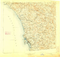
~ Southern California Sheet No 2 CA topo map, 1:250000 scale, 1 X 1 Degree, Historical, 1904, updated 1909
Southern California Sheet No 2, California, USGS topographic map dated 1904.
Includes geographic coordinates (latitude and longitude). This topographic map is suitable for hiking, camping, and exploring, or framing it as a wall map.
Printed on-demand using high resolution imagery, on heavy weight and acid free paper, or alternatively on a variety of synthetic materials.
Topos available on paper, Waterproof, Poly, or Tyvek. Usually shipping rolled, unless combined with other folded maps in one order.
- Product Number: USGS-5688568
- Free digital map download (high-resolution, GeoPDF): Southern California Sheet No 2, California (file size: 9 MB)
- Map Size: please refer to the dimensions of the GeoPDF map above
- Weight (paper map): ca. 55 grams
- Map Type: POD USGS Topographic Map
- Map Series: HTMC
- Map Verison: Historical
- Cell ID: 396038
- Scan ID: 299907
- Imprint Year: 1909
- Survey Year: 1902
- Datum: Unstated
- Map Projection: Unstated
- Map published by United States Geological Survey
- Map Language: English
- Scanner Resolution: 600 dpi
- Map Cell Name: Southern California Sheet No. 2
- Grid size: 1 X 1 Degree
- Date on map: 1904
- Map Scale: 1:250000
- Geographical region: California, United States
Neighboring Maps:
All neighboring USGS topo maps are available for sale online at a variety of scales.
Spatial coverage:
Topo map Southern California Sheet No 2, California, covers the geographical area associated the following places:
- Hawaiian Village Mobile Home Park - Mission del Magnolia Mobile Home Park - Barrett Junction - Laguna Junction - Vista - Rancho del Avion Capistrano Mobile Home Park - Solana Beach - Lemon Grove - Rainbow - Pleasant Valley Mobile Home Park - Green Valley - Village Green Trailer Park - Chollas Creek - Rancho Carlsbad Trailer Park - Otay Mesa - Mobile Haven Mobile Home Park - Encinitas - La Presa - Tiki Mobile Village - Sunset Terrace Mobile Home Park - Johnstown - Hacienda del Florasol - Brooklyn Heights - Rancho Alipaz Mobile Home Park - Mission Hills - Eastlake Greens - Fort Rosecrans - Sorrento - The Views Mobile Home Park - Rancho Penasquitos - Otay - Boulder Oaks - Julian - Shelltown - Sherman Heights - Nestor - Dana Point Marina Mobile Home Estates - Homelands - Chappo - La Jolla Amago - Linda Vista - Cajon Heights - El Camino 76 Trailer Park - Farr - La Jolla Shores - Barona - Flinn Springs - Phelps Corner - Fallbrook Junction - Rincon - Dehesa - Capistrano Valley Mobile Home Estates - Mussey Grove (historical) - Yaldora - Trico Mobile Estates - Blossom Valley - Don (historical) - Alpine - Town and Country Mobile Home Park - Ramona - Overlook - Eucalyptus Hills - Kentwood-In-The-Pines - Casa Grande Estates Mobile Home Park - North Jamul - Scripps Ranch - Buena - Five Points - Citrus Gardens Mobile Home Park - Lomita - El Capitan (historical) - Morena Village - Capistrano Terrace Mobile Home Park - Hidden Vale Mobile Home Park - Lincoln Park - Lake Bernardo Estates Mobile Home Park - Lake San Marcos - Sierra Vista Trailer Park - Santa Ysabel - Castle Park - Ponderosa Club Mobile Home Park - Canyon Crest Mobile Home Park - Doghouse Junction - Stallion Oaks - Mountain View - Riverview Farms - North Park - Lawrence Welk Resort Village - Pala - Mesa Grande - Green Tree Estates Mobile Home Park - North Bay Terraces - Winter Gardens - Warner Springs - Ridgecrest Estates - De Luz Heights - Meadowbrook Mobile Home Park - North Clairemont - Temecula Ranchos - Guatay
- Map Area ID: AREA33.532.5-117.75-116.5
- Northwest corner Lat/Long code: USGSNW33.5-117.75
- Northeast corner Lat/Long code: USGSNE33.5-116.5
- Southwest corner Lat/Long code: USGSSW32.5-117.75
- Southeast corner Lat/Long code: USGSSE32.5-116.5
- Northern map edge Latitude: 33.5
- Southern map edge Latitude: 32.5
- Western map edge Longitude: -117.75
- Eastern map edge Longitude: -116.5


