
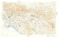
~ Southern California Sheet No 1 CA topo map, 1:250000 scale, 1 X 2 Degree, Historical, 1901, updated 1948
Southern California Sheet No 1, California, USGS topographic map dated 1901.
Includes geographic coordinates (latitude and longitude). This topographic map is suitable for hiking, camping, and exploring, or framing it as a wall map.
Printed on-demand using high resolution imagery, on heavy weight and acid free paper, or alternatively on a variety of synthetic materials.
Topos available on paper, Waterproof, Poly, or Tyvek. Usually shipping rolled, unless combined with other folded maps in one order.
- Product Number: USGS-5688564
- Free digital map download (high-resolution, GeoPDF): Southern California Sheet No 1, California (file size: 18 MB)
- Map Size: please refer to the dimensions of the GeoPDF map above
- Weight (paper map): ca. 55 grams
- Map Type: POD USGS Topographic Map
- Map Series: HTMC
- Map Verison: Historical
- Cell ID: 396058
- Scan ID: 302164
- Imprint Year: 1948
- Survey Year: 1900
- Datum: Unstated
- Map Projection: Polyconic
- Map published by United States Geological Survey
- Map Language: English
- Scanner Resolution: 600 dpi
- Map Cell Name: Southern California Sheet No. 1
- Grid size: 1 X 2 Degree
- Date on map: 1901
- Map Scale: 1:250000
- Geographical region: California, United States
Neighboring Maps:
All neighboring USGS topo maps are available for sale online at a variety of scales.
Spatial coverage:
Topo map Southern California Sheet No 1, California, covers the geographical area associated the following places:
- Arlanza - Maravilla Housing Project - East San Gabriel - Wanda (historical) - Sylvan Meadows - Azusa - Hancock Park - Declez - Brooklyn Heights - Lincoln Heights - Vernon - Carlton - Butler - West Covina - Lakeview Hot Springs - Newport Marina Mobile Home Park - Morton - Rana - Southwest Village - Nevin - North Norton - Paramount - El Monte - Commerce - Pico Gardens - South Laguna - Cajon Junction - Liberty Park - Rio Vista Mobile Home Estates - Etiwanda - Dominguez - Hyde Park - Cotners Corner - Winchester - San Sevaine (historical) - Molino - Cowan Heights - Athens - Santa Rosa South - Sunset Ridge - Dolanco Junction - West Rancho Dominguez - Angelino Heights - Quail Valley - Little Tokyo - West Hollywood - Woodcrest - Mount Baldy - San Pedro Hill - Upland - Norco - Brentwood - Maravilla - Browning - Shirley - Belvedere Heights - Rose Park - Meadowlark Mobile Home Estates - Sunset Hills - Murrieta Hot Springs - North Sherman Way - Goldcrest Mobile Home Club - Cedar Glen - Omaha Heights - Heritage Mobile Home Park - Van Ness - Hermosa Beach - Spring Valley Lake - Como - Smeltzer - Coto De Caza - Balboa - Anaheim Royal Mobile Home Park - Ennis - Nutwood - Halcon - Little Ethiopia - Friendly Village of Anaheim - Oakridge Ranches - Boyle Heights - Lugo - San Gabriel - Bandini - Anaheim - Sierra Madre - Cannery Village Mobile Home Park - California Mobile Home Park - Forest Falls - La Verne - Westwood Village - Santa Monica - Rialto - Sea Breeze Trailer Park - Prenda - Culver Junction - North El Monte - Plymouth Village - Cerro Villa Heights - Alessandro - Casa Loma
- Map Area ID: AREA34.533.5-118.5-116.5
- Northwest corner Lat/Long code: USGSNW34.5-118.5
- Northeast corner Lat/Long code: USGSNE34.5-116.5
- Southwest corner Lat/Long code: USGSSW33.5-118.5
- Southeast corner Lat/Long code: USGSSE33.5-116.5
- Northern map edge Latitude: 34.5
- Southern map edge Latitude: 33.5
- Western map edge Longitude: -118.5
- Eastern map edge Longitude: -116.5


