
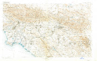
~ Southern California Sheet No 1 CA topo map, 1:250000 scale, 1 X 2 Degree, Historical, 1901, updated 1921
Southern California Sheet No 1, California, USGS topographic map dated 1901.
Includes geographic coordinates (latitude and longitude). This topographic map is suitable for hiking, camping, and exploring, or framing it as a wall map.
Printed on-demand using high resolution imagery, on heavy weight and acid free paper, or alternatively on a variety of synthetic materials.
Topos available on paper, Waterproof, Poly, or Tyvek. Usually shipping rolled, unless combined with other folded maps in one order.
- Product Number: USGS-5688562
- Free digital map download (high-resolution, GeoPDF): Southern California Sheet No 1, California (file size: 18 MB)
- Map Size: please refer to the dimensions of the GeoPDF map above
- Weight (paper map): ca. 55 grams
- Map Type: POD USGS Topographic Map
- Map Series: HTMC
- Map Verison: Historical
- Cell ID: 396058
- Scan ID: 299905
- Imprint Year: 1921
- Survey Year: 1900
- Datum: Unstated
- Map Projection: Unstated
- Map published by United States Geological Survey
- Map Language: English
- Scanner Resolution: 600 dpi
- Map Cell Name: Southern California Sheet No. 1
- Grid size: 1 X 2 Degree
- Date on map: 1901
- Map Scale: 1:250000
- Geographical region: California, United States
Neighboring Maps:
All neighboring USGS topo maps are available for sale online at a variety of scales.
Spatial coverage:
Topo map Southern California Sheet No 1, California, covers the geographical area associated the following places:
- Deer Haven - Mount Baldy - Dolores - Brea - Mission Hills - Daum (historical) - El Segundo - Carthay Circle - Barber City - Cowan Heights - Racimo - Home Gardens - Panorama Heights - Winchester - Vega - Lake Arrowhead - Harbor Mobile Home Park - Culver Garden - Running Springs - Smeltzer - Ravenna - Westgate Heights - Rancho las Perris - Blue Jay - Mountain Home Village - Stallion Meadow Mobile Home Park - Liberty Mobile Home Court - Devore - Magnolia Park - North Sherman Way - Big Rock Springs - Los Serranos - San Fernando - Talbert - Serrano Place - Lake Elsinore - Heart Bar Campground - Culver City - Scotland - Crystal Cove - Beverly Glen - Azusa - Nicklin - Fountain Valley Mobile Home Estates - Aurant - Halcon - Hoosier Trailer Court - Victoria - Gypsum (historical) - Tree Mobile Home Park - Canyon Country - Pine Wood - May - Guasti - Foothill Ranch - Walker - Garvanza - La Cuesta Fontana - North Fontana - Hacienda Mobile Home Park - Sedco Hills - Monaco - La Crescenta - Hewes Park - Galivan - North Shore - Raymer - Humphreys - Micaflores - Boulevard Gardens - Pico Gardens - Valyermo - The Mesa - Little Morongo Heights - Summit Terrace - Doble - Lugo - Silverado - Aliso Village - San Jacinto - Villa Capri Mobile Home Park - Cedar Glen - San Pedro - Corona del Mar - Rowland Heights - Romoland - West Anaheim Junction - Etiwanda - Anaheim Hills - Fairview Mobile Home Estates - Alray - Pepper Corner - Hyperion (historical) - Menifee - East Pasadena - Trabuco Highlands - East Arcadia - North Highland Park - Dolley - Montesilla Mobile Home Club
- Map Area ID: AREA34.533.5-118.5-116.5
- Northwest corner Lat/Long code: USGSNW34.5-118.5
- Northeast corner Lat/Long code: USGSNE34.5-116.5
- Southwest corner Lat/Long code: USGSSW33.5-118.5
- Southeast corner Lat/Long code: USGSSE33.5-116.5
- Northern map edge Latitude: 34.5
- Southern map edge Latitude: 33.5
- Western map edge Longitude: -118.5
- Eastern map edge Longitude: -116.5


