
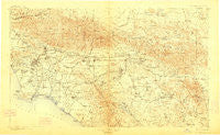
~ Southern California Sheet No 1 CA topo map, 1:250000 scale, 1 X 2 Degree, Historical, 1901, updated 1912
Southern California Sheet No 1, California, USGS topographic map dated 1901.
Includes geographic coordinates (latitude and longitude). This topographic map is suitable for hiking, camping, and exploring, or framing it as a wall map.
Printed on-demand using high resolution imagery, on heavy weight and acid free paper, or alternatively on a variety of synthetic materials.
Topos available on paper, Waterproof, Poly, or Tyvek. Usually shipping rolled, unless combined with other folded maps in one order.
- Product Number: USGS-5688560
- Free digital map download (high-resolution, GeoPDF): Southern California Sheet No 1, California (file size: 18 MB)
- Map Size: please refer to the dimensions of the GeoPDF map above
- Weight (paper map): ca. 55 grams
- Map Type: POD USGS Topographic Map
- Map Series: HTMC
- Map Verison: Historical
- Cell ID: 396058
- Scan ID: 299902
- Imprint Year: 1912
- Survey Year: 1900
- Datum: Unstated
- Map Projection: Unstated
- Map published by United States Geological Survey
- Map Language: English
- Scanner Resolution: 600 dpi
- Map Cell Name: Southern California Sheet No. 1
- Grid size: 1 X 2 Degree
- Date on map: 1901
- Map Scale: 1:250000
- Geographical region: California, United States
Neighboring Maps:
All neighboring USGS topo maps are available for sale online at a variety of scales.
Spatial coverage:
Topo map Southern California Sheet No 1, California, covers the geographical area associated the following places:
- The Mesa - Cannery Village Mobile Home Park - University Heights - Sea Breeze Trailer Park - Leimert Park - San Pedro Hill - Blue Jay - Buena Park - Los Robles Mobile Home Park - Country Road Estates - Dunlap Acres - Valley View Park - Westmont - Bryn Mawr - Wrightwood - Lake Crest Estates - Bannockburn Village - Arrowhead - Oak Glen - Balboa Island - Sierra Madre - Woodside Village - Porphyry - Coto De Caza - East Pasadena - Ponderosa Mobile Home Park - Loma Linda - Kester - Harbor Mobile Home Park - Soto Street Junction - Altacanyada - Sahara Mobile Home Park - Highgrove - Whittier - Nuevo - Guasti - Butte Street Junction - Las Uvas (historical) - Heritage Mobile Home Park - West Athens - Rendalia - Soledad Sulphur Springs (historical) - El Modena - Edendale (historical) - Charter Oak Mobile Estates - Weisel - Morton - Machado (historical) - Del Rosa - Dolley - El Monte - La Paloma - Vega - Sun City - Adams Square - Pedley - Arrowhead Equestrian Estates - Dyer - University Village - Arrowhead Farms - Anaheim Shores - Glendale - Racimo - Montclair - Villa Grande Mobile Home Park - Kimberly Gardens Mobile Home Park - Morningside Park - Otterbein - Arrowbear Lake - White Water - Honby - Maxson - Sibagna (historical) - Costa Mesa Mobile Home Estates - Foothill Ranch - Talbert - La Belle Fontane Estates - Silver Lake Heights - Pueblo Del Rio Public Housing - Del Cerro Mobile Home Estates - Alpine (historical) - Culver Junction - South Los Angeles - Ennis - Plymouth Village - Eden Hot Springs - Huntington Shorecliffs Mobile Home Park - Walker - El Casco - South Grove Mobile Home Estates - Newport Marina Mobile Home Park - Crestline - Spadra - Homeland - La Fetra - Rancho La Paz - Alray - Tujunga - Villa Magnolia Mobile Home Park - Arroyo Fairways Mobile Home Club
- Map Area ID: AREA34.533.5-118.5-116.5
- Northwest corner Lat/Long code: USGSNW34.5-118.5
- Northeast corner Lat/Long code: USGSNE34.5-116.5
- Southwest corner Lat/Long code: USGSSW33.5-118.5
- Southeast corner Lat/Long code: USGSSE33.5-116.5
- Northern map edge Latitude: 34.5
- Southern map edge Latitude: 33.5
- Western map edge Longitude: -118.5
- Eastern map edge Longitude: -116.5


