
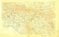
~ Southern California Sheet No 1 CA topo map, 1:250000 scale, 1 X 2 Degree, Historical, 1904, updated 1907
Southern California Sheet No 1, California, USGS topographic map dated 1904.
Includes geographic coordinates (latitude and longitude). This topographic map is suitable for hiking, camping, and exploring, or framing it as a wall map.
Printed on-demand using high resolution imagery, on heavy weight and acid free paper, or alternatively on a variety of synthetic materials.
Topos available on paper, Waterproof, Poly, or Tyvek. Usually shipping rolled, unless combined with other folded maps in one order.
- Product Number: USGS-5688556
- Free digital map download (high-resolution, GeoPDF): Southern California Sheet No 1, California (file size: 18 MB)
- Map Size: please refer to the dimensions of the GeoPDF map above
- Weight (paper map): ca. 55 grams
- Map Type: POD USGS Topographic Map
- Map Series: HTMC
- Map Verison: Historical
- Cell ID: 396058
- Scan ID: 299899
- Imprint Year: 1907
- Survey Year: 1900
- Datum: Unstated
- Map Projection: Unstated
- Map published by United States Geological Survey
- Map Language: English
- Scanner Resolution: 600 dpi
- Map Cell Name: Southern California Sheet No. 1
- Grid size: 1 X 2 Degree
- Date on map: 1904
- Map Scale: 1:250000
- Geographical region: California, United States
Neighboring Maps:
All neighboring USGS topo maps are available for sale online at a variety of scales.
Spatial coverage:
Topo map Southern California Sheet No 1, California, covers the geographical area associated the following places:
- Cottage Gardens - Moody - Greenleaf Mobile Home Park - Rio Vista Mobile Home Estates - Wahoo (historical) - Orange Mobile Home Park - Prothero Mobile Home Park - Irvine - Sparr Heights - Meadowbrook Woods - Montrose - Fizzben Heights - Warm Springs Mobile Home Park - Gage - Nadeau - Charter Oak Mobile Estates - Sylmar - Walteria - Bolsa Verde - Lamanda Park - Crafton - Covina - Cypress - Bradbury - Bridgedale - Moonridge - Olinda (historical) - Mountain Home Village - Ontario - Vineyard - The Gables - Fuller Park - Paramount - Wilmington - San Dimas - Corona del Mar - Stonehurst - Mariana Ranchos - Villa Capri Mobile Home Park - Avalon Gardens - Sunset Ridge - Cypress Park - East Irvine - Ennis - Valley Vista - Murrieta Hot Springs - Stallion Meadow Mobile Home Park - Henshaw - La Puente - Mount Baldy - Redondo Junction - Laguna - Cowan Heights - Pasadena - Valyermo - Palm Lodge Mobile Home Estates - Huntington Mobile Home Estates - Paradise Springs - Old Chinatown (historical) - Bel Air - Falling Springs (historical) - City Terrace - Anaheim Royal Mobile Home Park - Rancho las Perris - El Segundo - Lakeland Village - Roosevelt - Gavilan Hills - Seal Beach - Ailsa (historical) - Pine Wood - Whittier Junction - Evergreen (historical) - Country Mobile Estates - Signal Hill - La Cañada Flintridge - Hawthorne - South Whittier - Trabuco Canyon - Los Serranos - Monterey Park - California Mobile Home Park - Mountain Top Junction - Wrightwood - Snow Creek - Golden Valley Acres - Dolores - Laguna Beach - Daum (historical) - Santa Rosa Ranch Estates - Leimert Park - Hacienda Mobile Home Park - Driftwood Mobile Home Park - Des Moines - Lakeview Hot Springs - Mayflower Village - Century City - Oak Hills - Lake Elsinore - Creekside
- Map Area ID: AREA34.533.5-118.5-116.5
- Northwest corner Lat/Long code: USGSNW34.5-118.5
- Northeast corner Lat/Long code: USGSNE34.5-116.5
- Southwest corner Lat/Long code: USGSSW33.5-118.5
- Southeast corner Lat/Long code: USGSSE33.5-116.5
- Northern map edge Latitude: 34.5
- Southern map edge Latitude: 33.5
- Western map edge Longitude: -118.5
- Eastern map edge Longitude: -116.5


