
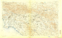
~ Southern California Sheet No 1 CA topo map, 1:250000 scale, 1 X 2 Degree, Historical, 1901, updated 1905
Southern California Sheet No 1, California, USGS topographic map dated 1901.
Includes geographic coordinates (latitude and longitude). This topographic map is suitable for hiking, camping, and exploring, or framing it as a wall map.
Printed on-demand using high resolution imagery, on heavy weight and acid free paper, or alternatively on a variety of synthetic materials.
Topos available on paper, Waterproof, Poly, or Tyvek. Usually shipping rolled, unless combined with other folded maps in one order.
- Product Number: USGS-5688554
- Free digital map download (high-resolution, GeoPDF): Southern California Sheet No 1, California (file size: 18 MB)
- Map Size: please refer to the dimensions of the GeoPDF map above
- Weight (paper map): ca. 55 grams
- Map Type: POD USGS Topographic Map
- Map Series: HTMC
- Map Verison: Historical
- Cell ID: 396058
- Scan ID: 299898
- Imprint Year: 1905
- Datum: Unstated
- Map Projection: Unstated
- Map published by United States Geological Survey
- Map Language: English
- Scanner Resolution: 600 dpi
- Map Cell Name: Southern California Sheet No. 1
- Grid size: 1 X 2 Degree
- Date on map: 1901
- Map Scale: 1:250000
- Geographical region: California, United States
Neighboring Maps:
All neighboring USGS topo maps are available for sale online at a variety of scales.
Spatial coverage:
Topo map Southern California Sheet No 1, California, covers the geographical area associated the following places:
- Sugarloaf - Westgate - Moreno Knolls - Nevada - Palm Wells - New Chinatown - Arlington Station - Laguna Hills - Menifee - Bonnie Bell - Sierra Heights - Hesperia - Sea Aria East Mobile Home Estates - Running Springs - Ironsides - Evergreen (historical) - Lake View Terrace - Racimo - Bahia Trailer Villa - Three Points - Avalon Gardens - Fizzben Heights - Chapman - Santa Fe Springs - Hollywood Riviera - Cowan Heights - Villa Grande Mobile Home Park - Bingham - Indian Oaks - Lake Park Santa Ana - Quail Valley - Cypress Grove - Sunnyslope - Beaumont - Wingfoot - Sleepy Hollow - Century City - Juniper Springs - Lido Isle - Como - Serrano Place - Lucerne Valley - Alla - Creekside Mobile Home Estates - Thorn - Santa Ana - Garvanza - Bradbury - Culver City - Canyon Country - North Long Beach - Rubidoux - McNeil - Willowick Royal Mobile Home Park - Las Lomas - Panorama Heights - Arrowhead Springs - Eden - Olinda (historical) - South Los Angeles - Minnelusa - Parque Santiago Mobile Home Park - Wanda (historical) - Grand Terrace - Lugo - Las Uvas (historical) - Ellis - Paris - Upland - Lemona - Pinezanita - Stoneridge Mobile Home Park - Kagel Canyon - Rowland Heights - El Segundo - Warner - Ninth Street Junction - Edendale (historical) - Norco - Collins (historical) - Graham - Venice - Mountain Center - Murrieta - Sunnymead - Dana Strand Village - Parque Pacifico Mobile Home Park - La Belle Fontane Estates - Dominguez Junction - Lytle Creek - Big Bear Lake - San Gabriel - Brookfield Manor Mobile Home Park - Lemon Heights - Tustin Village Mobile Home Club - Alta Loma - North Ontario - Mountain View Acres - Seal Beach - El Morro Beach Trailer Park (historical)
- Map Area ID: AREA34.533.5-118.5-116.5
- Northwest corner Lat/Long code: USGSNW34.5-118.5
- Northeast corner Lat/Long code: USGSNE34.5-116.5
- Southwest corner Lat/Long code: USGSSW33.5-118.5
- Southeast corner Lat/Long code: USGSSE33.5-116.5
- Northern map edge Latitude: 34.5
- Southern map edge Latitude: 33.5
- Western map edge Longitude: -118.5
- Eastern map edge Longitude: -116.5


