
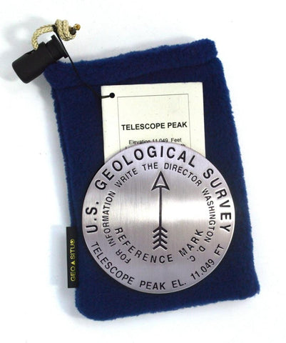
Telescope Peak, Death Valley National Park, California paperweight
3 1/4 inch diameter
Cast in fine pewter
Felt backing
With soft fleece pouch
In clear-vinyl covered box
PLACE NAME: Telescope Peak
ELEVATION: 11,049 ft.
COORDINATES: N36° 10 11 W117° 05 16
LOCATION: Death Valley National Monument, California, USA
MARKERSLEUTH PHOTO CONTRIBUTOR: Andrew Pelz, 1997
Telescope Peak, at 11,049 feet, is the highest point of Death Valley National Monument. The elevation gain from the valley floor to the summit is over 11,300 feet. In the USA, only Mt. Rainier, Mt. Fairweather, and Mt. McKinley boast greater elevation gain. Its summit is snow-covered from mid-November to mid-April making it unavailable except to experienced and well-equipped climbers. All are advised to be well prepared.
Death Valley and its surrounding mountain ranges, the Panamint and Black Mountains, are considered basin and range country. Geologic forces have separated and tilted the ranges and created a basin between them. The area boasts the
- Product Number: GSU_PW_TELESCOPE
- Reference Product Number: 2306185M
- ISBN: - None -
- Map format: - None -
- Map type: Accessories - Other Accessories
- Geographical region: United States
- Geographical subregion: California


