
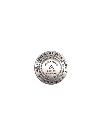
Mt. Tamalpais, California lapel pin
1 inch diameter
Cast in fine pewter
Military clutch back
Mounted on story card
PLACE NAME: Mount Tamalpais
ELEVATION: 2571 ft.
COORDINATES: N37° 55 45 W122° 34 34
LOCATION: Mount Tamalpais State Park, California, USA
This mark was inspired by the survey mark found near the lookout tower at the summit of Mount Tamalpais, located in the heart of Marin County, north of San Franciscos Golden Gate. Mount Tamalpais is not volcanic. It was formed by the tremendous grinding tectonic pressures where the Geologic North American and Pan Pacific plates meet. Tamalpais is unique in that it runs East and West. The name tamalpais is thought by some to be a combination of two Coast Miwok Indian words: tamal (bay, or coast) and pais (mountain).
- Product Number: GSU_PN_TAMAL
- Reference Product Number: 2306045M
- ISBN: - None -
- Map format: - None -
- Map type: Accessories - Pins
- Geographical region: United States
- Geographical subregion: California


