
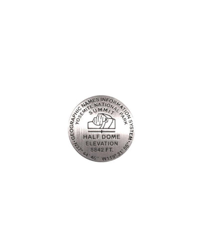
Half Dome GNIS, California lapel pin
1 inch diameter
Cast in fine pewter
Military clutch back
Mounted on story card
PLACE NAME: Half Dome
ELEVATION: 8,842 ft.
COORDINATES: N37° 44 46 W119° 31 55
LOCATION: Yosemite National Park, California, USA
Yosemite Valley, about 3,000 feet deep and just a mile or two wide, is known for its landmark rock formations. Half Dome is perhaps the most recognized and sought after. Visitors planning a hike to the top are assisted with cables anchored securely in the massive monolith. Even so, the 17 mile round trip is challenging and requires caution, fitness and endurance. Half Dome can be seen throughout eastern Yosemite Valley and from Glacier Point. Alternate names include Frances Peak, Rock of Ages, Tesayac, and To-co-ya.
Whats in a name? Plenty! This medallion displays data from the official United States data source on domestic geographic names, Geographic Names Information System (GNIS). The database is useful to earth science professionals, m
- Product Number: GSU_PN_HALF
- Reference Product Number: 2305999M
- ISBN: - None -
- Map format: - None -
- Map type: Accessories - Pins
- Geographical region: United States
- Geographical subregion: California


