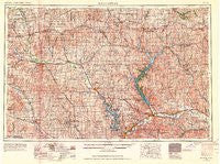
~ Manhattan KS topo map, 1:250000 scale, 1 X 2 Degree, Historical, 1955, updated 1964
Manhattan, Kansas, USGS topographic map dated 1955.
Includes geographic coordinates (latitude and longitude). This topographic map is suitable for hiking, camping, and exploring, or framing it as a wall map.
Printed on-demand using high resolution imagery, on heavy weight and acid free paper, or alternatively on a variety of synthetic materials.
Topos available on paper, Waterproof, Poly, or Tyvek. Usually shipping rolled, unless combined with other folded maps in one order.
- Product Number: USGS-5972334
- Free digital map download (high-resolution, GeoPDF): Manhattan, Kansas (file size: 13 MB)
- Map Size: please refer to the dimensions of the GeoPDF map above
- Weight (paper map): ca. 55 grams
- Map Type: POD USGS Topographic Map
- Map Series: HTMC
- Map Verison: Historical
- Cell ID: 72237
- Scan ID: 801880
- Imprint Year: 1964
- Woodland Tint: Yes
- Aerial Photo Year: 1954
- Edit Year: 1964
- Field Check Year: 1955
- Datum: NAD27
- Map Projection: Transverse Mercator
- Map published by United States Army Corps of Engineers
- Map published by United States Army
- Map Language: English
- Scanner Resolution: 508 dpi
- Map Cell Name: Manhattan
- Grid size: 1 X 2 Degree
- Date on map: 1955
- Map Scale: 1:250000
- Geographical region: Kansas, United States
Neighboring Maps:
All neighboring USGS topo maps are available for sale online at a variety of scales.
Spatial coverage:
Topo map Manhattan, Kansas, covers the geographical area associated the following places:
- Elm Hollow Corner - Rocky Ford Mobile Home Park - Beckerville - Summerfield - Corning - Maple Hill - Bluemont Hill - Herkimer - Hanover - Rosaco - Kelly - America City - Scandia - Ada - Clyde - Junction City Regency Mobile Home Park - Baileyville - Aurora - Palmer - Seneca - Aikins - Saint Benedict - Rocky Ford - Beattie - Louisville - Greenleaf - Ogden - Shroyer - Vine Creek - Paxico - Garfield Center - Grandview Plaza - Linn - Blue Valley Mobile Home Park - Formoso - Hawks Landing Mobile Home Park - Leonardville - Saint George - Winifred - Barnes - Oneonta (historical) - Vermillion - Alma - Wabaunsee - Randolph - Cottonwood Mobile Home Estates - Norway - Olsburg - Westmoreland - Kimeo - Keats - Alcove Spring - Vliets - Haworth - Flush - Jamestown - Scottish Square Mobile Home Park - Riverchase Mobile Home Park - Walsburg - Harbine - Alfmil - Moonlight - Kackley - Summit - Ashwood Mobile Home Park - Belvue - Concordia - Talmo - Centralia - Talmage - Riley - Barret - Minneapolis - Carden - Belleville - Narka - Washington - Lovewell - Country Gardens Mobile Home Park - Mobile Villa Trailer Court - Vining - Frankfort - Manchester - Milford - Country Acres Trailer Court - Black Squirrel Mobile Home Park - Morrowville - Industry - Buckeye - Oak Hill - Wheaton - Vera - Fairmont - Strawberry - Calderhead - Neuchatel - Wells - Newbury - Lakeside Mobile Home Court - Marysville
- Map Area ID: AREA4039-98-96
- Northwest corner Lat/Long code: USGSNW40-98
- Northeast corner Lat/Long code: USGSNE40-96
- Southwest corner Lat/Long code: USGSSW39-98
- Southeast corner Lat/Long code: USGSSE39-96
- Northern map edge Latitude: 40
- Southern map edge Latitude: 39
- Western map edge Longitude: -98
- Eastern map edge Longitude: -96