
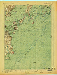
~ Casco Bay ME topo map, 1:62500 scale, 15 X 15 Minute, Historical, 1916, updated 1925
Casco Bay, Maine, USGS topographic map dated 1916.
Includes geographic coordinates (latitude and longitude). This topographic map is suitable for hiking, camping, and exploring, or framing it as a wall map.
Printed on-demand using high resolution imagery, on heavy weight and acid free paper, or alternatively on a variety of synthetic materials.
Topos available on paper, Waterproof, Poly, or Tyvek. Usually shipping rolled, unless combined with other folded maps in one order.
- Product Number: USGS-5536281
- Free digital map download (high-resolution, GeoPDF): Casco Bay, Maine (file size: 5 MB)
- Map Size: please refer to the dimensions of the GeoPDF map above
- Weight (paper map): ca. 55 grams
- Map Type: POD USGS Topographic Map
- Map Series: HTMC
- Map Verison: Historical
- Cell ID: 52243
- Scan ID: 807432
- Imprint Year: 1925
- Survey Year: 1914
- Datum: NAD
- Map Projection: Polyconic
- Map published by United States Geological Survey
- Map Language: English
- Scanner Resolution: 508 dpi
- Map Cell Name: Casco Bay
- Grid size: 15 X 15 Minute
- Date on map: 1916
- Map Scale: 1:62500
- Geographical region: Maine, United States
Neighboring Maps:
All neighboring USGS topo maps are available for sale online at a variety of scales.
Spatial coverage:
Topo map Casco Bay, Maine, covers the geographical area associated the following places:
- Long Island - Meeting House Hill - Western Landing - York Landing - Fort Lyon - Falmouth - Peaks Island - Sunset Landing - Pond Cove - Chandler Cove Landing - Loveitts Field - Fort Gorges - Ferry Village - Cleaves Landing - East End - Falmouth Foreside - Great Diamond Island Landing - Munjoy Hill - Delano Park - Jones Wharf - Cape Elizabeth - Little Diamond Island Landing - Central Landing - Fort Scammel - Jenks Landing - Willard Square - South Portland - Doughty Landing - Trefethen - Chebeague Island - McKinley Estates - Evergreen Landing - Fort Preble - Elizabeth Park - South Harpswell - Cliff Island Landing - Cushing Island - Waites Landing - Cape Cottage - Cliff Island - Fort Levett - Mountainview Park - Ponce Landing - Mariner
- Map Area ID: AREA43.7543.5-70.25-70
- Northwest corner Lat/Long code: USGSNW43.75-70.25
- Northeast corner Lat/Long code: USGSNE43.75-70
- Southwest corner Lat/Long code: USGSSW43.5-70.25
- Southeast corner Lat/Long code: USGSSE43.5-70
- Northern map edge Latitude: 43.75
- Southern map edge Latitude: 43.5
- Western map edge Longitude: -70.25
- Eastern map edge Longitude: -70


