
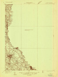
~ Berwick ME topo map, 1:48000 scale, 15 X 15 Minute, Historical, 1933
Berwick, Maine, USGS topographic map dated 1933.
Includes geographic coordinates (latitude and longitude). This topographic map is suitable for hiking, camping, and exploring, or framing it as a wall map.
Printed on-demand using high resolution imagery, on heavy weight and acid free paper, or alternatively on a variety of synthetic materials.
Topos available on paper, Waterproof, Poly, or Tyvek. Usually shipping rolled, unless combined with other folded maps in one order.
- Product Number: USGS-5535957
- Free digital map download (high-resolution, GeoPDF): Berwick, Maine (file size: 6 MB)
- Map Size: please refer to the dimensions of the GeoPDF map above
- Weight (paper map): ca. 55 grams
- Map Type: POD USGS Topographic Map
- Map Series: HTMC
- Map Verison: Historical
- Cell ID: 51254
- Scan ID: 806502
- Survey Year: 1933
- Datum: NAD
- Map Projection: Polyconic
- Advance: Yes
- Map published by United States Geological Survey
- Keywords: Nonstandard Press Run
- Map Language: English
- Scanner Resolution: 508 dpi
- Map Cell Name: Berwick
- Grid size: 15 X 15 Minute
- Date on map: 1933
- Map Scale: 1:48000
- Geographical region: Maine, United States
Neighboring Maps:
All neighboring USGS topo maps are available for sale online at a variety of scales.
Spatial coverage:
Topo map Berwick, Maine, covers the geographical area associated the following places:
- Newichawanoc (historical) - East Lebanon - Center Lebanon - Emery Mills - Laskey Corner - East Rochester - Miller Corner - Fernald Shore - South Lebanon - North Rochester - Estes Hill - Foundry - Pickering - Berwick - North Lebanon - Rochester - Springvale - Town House - Lebanon - Blaisdell Corners - Melrose Corner - West Gonic - Sanford - Gonic - Five Corners - West Lebanon - Milton - Somersworth
- Map Area ID: AREA43.543.25-71-70.75
- Northwest corner Lat/Long code: USGSNW43.5-71
- Northeast corner Lat/Long code: USGSNE43.5-70.75
- Southwest corner Lat/Long code: USGSSW43.25-71
- Southeast corner Lat/Long code: USGSSE43.25-70.75
- Northern map edge Latitude: 43.5
- Southern map edge Latitude: 43.25
- Western map edge Longitude: -71
- Eastern map edge Longitude: -70.75


