
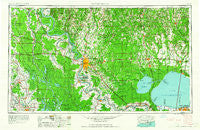
~ Baton Rouge LA topo map, 1:250000 scale, 1 X 2 Degree, Historical, 1962, updated 1962
Baton Rouge, Louisiana, USGS topographic map dated 1962.
Includes geographic coordinates (latitude and longitude). This topographic map is suitable for hiking, camping, and exploring, or framing it as a wall map.
Printed on-demand using high resolution imagery, on heavy weight and acid free paper, or alternatively on a variety of synthetic materials.
Topos available on paper, Waterproof, Poly, or Tyvek. Usually shipping rolled, unless combined with other folded maps in one order.
- Product Number: USGS-5595166
- Free digital map download (high-resolution, GeoPDF): Baton Rouge, Louisiana (file size: 19 MB)
- Map Size: please refer to the dimensions of the GeoPDF map above
- Weight (paper map): ca. 55 grams
- Map Type: POD USGS Topographic Map
- Map Series: HTMC
- Map Verison: Historical
- Cell ID: 68664
- Scan ID: 335210
- Imprint Year: 1962
- Woodland Tint: Yes
- Aerial Photo Year: 1954
- Edit Year: 1961
- Field Check Year: 1954
- Datum: Unstated
- Map Projection: Transverse Mercator
- Map published by United States Army
- Map Language: English
- Scanner Resolution: 600 dpi
- Map Cell Name: Baton Rouge
- Grid size: 1 X 2 Degree
- Date on map: 1962
- Map Scale: 1:250000
- Geographical region: Louisiana, United States
Neighboring Maps:
All neighboring USGS topo maps are available for sale online at a variety of scales.
Spatial coverage:
Topo map Baton Rouge, Louisiana, covers the geographical area associated the following places:
- Bonaire - Walden - Frost - Greenville - Beaud - Grand Annse - Knapp - Staring Acres - Cimmaron - Eastland - Segura - Des Glaise - Landry (historical) - Lake Oaks - Marwede - Lobdell Station - Shaw (historical) - Woodstone Estates - Anchor - Corbin - Afton Oaks - Jena (historical) - Greendale - Plaucheville - Parkview Oaks - Bluff Creek - Lula - Perkins Village - White Castle - Briarwood Estates - Sunnybrook - Denham Springs - Dude's Trailer Park - Tristian Village - Williamsport - Cedarcrest Mobile Home Park - Avalon Terrace - Twin Oaks - Bruns - Laurel Hill - Pointe Claire - Allemania - Carville - Breaux Bridge - Tolbert Place - Taterville - Bakerfield - Sherrington Place - Mannheim (historical) - Turnbull - McLemore Acres - Lynwood Village - Oak Ridge - Rolling Acres - Woodcrest - Lutcher - Thibodeaux Mobile Home Park - Ramsay - Prescott Place - Frisco - The Woodlands - Fulda (historical) - Sharon Hills - Saint Amant - Torras Landing - Parks - Walroy - Twin Oaks Mobile Home Park - Tally Ho - Oak Shadows Place - Purvis (historical) - Essen - The Shire - Bayou Paul - Choctaw Mobile Home Park - Morrisonville - Oscar - Ventress - Boganvilla - Saint Elmo - Gondron (historical) - Elks - Sharkey - Ardenwood - Bruces Mobile Home Park - Lynn's Mobile Home Court - Village Saint George - Saint Elmo - Beacon Hill - Yellow Bayou - Silverside Heights Garden - Wallace Landing - The Woods - Horse Bluff Landing - Milneburg - Magnolia Heights - Clifton - Woods Edge - Eliza - Baker Estates
- Map Area ID: AREA3130-92-90
- Northwest corner Lat/Long code: USGSNW31-92
- Northeast corner Lat/Long code: USGSNE31-90
- Southwest corner Lat/Long code: USGSSW30-92
- Southeast corner Lat/Long code: USGSSE30-90
- Northern map edge Latitude: 31
- Southern map edge Latitude: 30
- Western map edge Longitude: -92
- Eastern map edge Longitude: -90


