
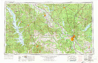
~ Alexandria LA topo map, 1:250000 scale, 1 X 2 Degree, Historical, 1953, updated 1975
Alexandria, Louisiana, USGS topographic map dated 1953.
Includes geographic coordinates (latitude and longitude). This topographic map is suitable for hiking, camping, and exploring, or framing it as a wall map.
Printed on-demand using high resolution imagery, on heavy weight and acid free paper, or alternatively on a variety of synthetic materials.
Topos available on paper, Waterproof, Poly, or Tyvek. Usually shipping rolled, unless combined with other folded maps in one order.
- Product Number: USGS-5595158
- Free digital map download (high-resolution, GeoPDF): Alexandria, Louisiana (file size: 21 MB)
- Map Size: please refer to the dimensions of the GeoPDF map above
- Weight (paper map): ca. 55 grams
- Map Type: POD USGS Topographic Map
- Map Series: HTMC
- Map Verison: Historical
- Cell ID: 68641
- Scan ID: 335206
- Imprint Year: 1975
- Woodland Tint: Yes
- Aerial Photo Year: 1972
- Edit Year: 1973
- Field Check Year: 1953
- Datum: Unstated
- Map Projection: Transverse Mercator
- Map published by United States Army
- Map Language: English
- Scanner Resolution: 600 dpi
- Map Cell Name: Alexandria
- Grid size: 1 X 2 Degree
- Date on map: 1953
- Map Scale: 1:250000
- Geographical region: Louisiana, United States
Neighboring Maps:
All neighboring USGS topo maps are available for sale online at a variety of scales.
Spatial coverage:
Topo map Alexandria, Louisiana, covers the geographical area associated the following places:
- Fairmount - Fisher - Mount Zion - Janie - Spider (historical) - Odom (historical) - Kurthwood - Clare - Spaulding - Kraft - Simpson - Barham - Calvert Acres - Old Montgomery (historical) - Clear Lake (historical) - Sharp - Coburn - Howcott - Weil - Five Forks - Nickel - Kateland - Gardner - Magasco - Billy Goat Hill - Cedar Grove - Inglewood - Melrose - Wheeling - McElroy - Antonia - Winnfield - Cloutierville - Boyce - Hargis - Hagen (historical) - Salt (historical) - Rattan - Coopers - Calvin - Henryville (historical) - Lee Heights - Fern - Flat Creek - Gandy - Campti - Timon - Brookeland - Anandale - Weeks Settlement - Otis - East Natchitoches - Worsham Crossing - Spring Ridge - Bethel - Tullos - Leesville - Pleasant Hill - Powell Park - Lake End - Hood - Jacksonville (historical) - Magda (historical) - Pollock - Logansport - Long Bridge - Latanier - Sardis - Rock Hill - Curry - Scrapping Valley - Tannehill - Stay - Provencal - Smithville - Redoak - Sartori (historical) - Moller - Hemphill - Florien - Many - Sieper - Oakleaf Estates - Benson - Toledo - Barrett - Milford (historical) - Mitchell - Emden - Shamrock - Beal Crossing - Collins - Jordans Store - Old Pleasant Hill - Iatt - Moreland - Eden - Converse - Clarence - Oak Grove
- Map Area ID: AREA3231-94-92
- Northwest corner Lat/Long code: USGSNW32-94
- Northeast corner Lat/Long code: USGSNE32-92
- Southwest corner Lat/Long code: USGSSW31-94
- Southeast corner Lat/Long code: USGSSE31-92
- Northern map edge Latitude: 32
- Southern map edge Latitude: 31
- Western map edge Longitude: -94
- Eastern map edge Longitude: -92


