
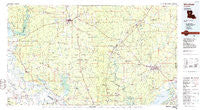
~ Winnfield LA topo map, 1:100000 scale, 30 X 60 Minute, Historical, 1986, updated 1986
Winnfield, Louisiana, USGS topographic map dated 1986.
Includes geographic coordinates (latitude and longitude). This topographic map is suitable for hiking, camping, and exploring, or framing it as a wall map.
Printed on-demand using high resolution imagery, on heavy weight and acid free paper, or alternatively on a variety of synthetic materials.
Topos available on paper, Waterproof, Poly, or Tyvek. Usually shipping rolled, unless combined with other folded maps in one order.
- Product Number: USGS-5595146
- Free digital map download (high-resolution, GeoPDF): Winnfield, Louisiana (file size: 21 MB)
- Map Size: please refer to the dimensions of the GeoPDF map above
- Weight (paper map): ca. 55 grams
- Map Type: POD USGS Topographic Map
- Map Series: HTMC
- Map Verison: Historical
- Cell ID: 68606
- Scan ID: 335200
- Imprint Year: 1986
- Woodland Tint: Yes
- Aerial Photo Year: 1982
- Edit Year: 1986
- Datum: NAD27
- Map Projection: Universal Transverse Mercator
- Planimetric: Yes
- Map published by United States Geological Survey
- Map Language: English
- Scanner Resolution: 600 dpi
- Map Cell Name: Winnfield
- Grid size: 30 X 60 Minute
- Date on map: 1986
- Map Scale: 1:100000
- Geographical region: Louisiana, United States
Neighboring Maps:
All neighboring USGS topo maps are available for sale online at a variety of scales.
Spatial coverage:
Topo map Winnfield, Louisiana, covers the geographical area associated the following places:
- Fellowship - Montrose - Fern - Breezy Hill - Melrose - Wetzlar - Whitford - Eden - Camp Hardtner - Derry - Phillips (historical) - Black Creek (historical) - Aloha - Kadesh - Mount Zion - Lakeview - Flat Creek - Holum - Grant (historical) - Ganeyville - Couley - Searcy - Trout - Magnolia - Givens (historical) - Marco - Farmland - Rogers - Routon - Mudville - Cane - Davis (historical) - Atlanta - Union Hill - Luella - Clear Lake (historical) - Lincecum - Tullos - Boley - Lutes - Mars Hill - Little Creek - Summerville - Menefee - Hester - Winnfield - Tansey - Urania - Good Pine - Odra - Montgomery - Packton - Whitehall - Pollock - Howcott - Antonia - Summerfield - Billis (historical) - Tannehill - Magnolia - Zion - Sand Spur - Wheeling - Tunica (historical) - Trichell - Dry Prong - Emden - Tide (historical) - Jordan Hill - Hatfield - Calvin - Colfax - Fishville - Worsham Crossing - Selma - Manistee (historical) - Zenoria - Fairfield - Oak Grove - Cloutierville - Grandstaff - Webb Quarters - Bentley - Five Forks - Royal - Colgrade - Pleasant Hill (historical) - Smith (historical) - Williams Corner (historical) - Sardis - Midway - Beech (historical) - Verda - Waddel - Moore - The Rock - Prairie Home (historical) - Williana - Saint Maurice - Belah
- Map Area ID: AREA3231.5-93-92
- Northwest corner Lat/Long code: USGSNW32-93
- Northeast corner Lat/Long code: USGSNE32-92
- Southwest corner Lat/Long code: USGSSW31.5-93
- Southeast corner Lat/Long code: USGSSE31.5-92
- Northern map edge Latitude: 32
- Southern map edge Latitude: 31.5
- Western map edge Longitude: -93
- Eastern map edge Longitude: -92


