
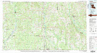
~ Amite LA topo map, 1:100000 scale, 30 X 60 Minute, Historical, 1983, updated 1983
Amite, Louisiana, USGS topographic map dated 1983.
Includes geographic coordinates (latitude and longitude). This topographic map is suitable for hiking, camping, and exploring, or framing it as a wall map.
Printed on-demand using high resolution imagery, on heavy weight and acid free paper, or alternatively on a variety of synthetic materials.
Topos available on paper, Waterproof, Poly, or Tyvek. Usually shipping rolled, unless combined with other folded maps in one order.
- Product Number: USGS-5595060
- Free digital map download (high-resolution, GeoPDF): Amite, Louisiana (file size: 26 MB)
- Map Size: please refer to the dimensions of the GeoPDF map above
- Weight (paper map): ca. 55 grams
- Map Type: POD USGS Topographic Map
- Map Series: HTMC
- Map Verison: Historical
- Cell ID: 67044
- Scan ID: 335153
- Imprint Year: 1983
- Woodland Tint: Yes
- Aerial Photo Year: 1979
- Edit Year: 1983
- Datum: NAD27
- Map Projection: Universal Transverse Mercator
- Map published by United States Geological Survey
- Map Language: English
- Scanner Resolution: 600 dpi
- Map Cell Name: Amite
- Grid size: 30 X 60 Minute
- Date on map: 1983
- Map Scale: 1:100000
- Geographical region: Louisiana, United States
Neighboring Maps:
All neighboring USGS topo maps are available for sale online at a variety of scales.
Spatial coverage:
Topo map Amite, Louisiana, covers the geographical area associated the following places:
- Holton - Springhill - Amite - Hackley - Felps - Pine Grove - Thomas - Richardson - Greenlaw - Uneedus - Marburyville (historical) - Husser - Watson - Mount Hermon - Gullett - Hollyridge - Whiskey Lane Mobile Home Park - Hillsdale - Willis - Baptist - Tallow Wood - Baywood - Satsuma - Kentwood - Roseland - Mitchell - Independence - Doyle - Northwoods - Magnolia Bend - Viola (historical) - Watson Estates Mobile Home Park - University Place - Livingston - Clifton - Grangeville - Lorraine - Oaknolia - Ramsay - Cumnock (historical) - Liverpool - Franklinton - Friendship - Natalbany - Porters Curve - Osceola - Velma - Albany - Warnerton - Martinville - Wilmer - Hammond - Superior Mobile Home Park - Bellingrath Hills - Woodbridge - Magnolia - Strawberry Heights Mobile Home Park - Easleyville - Tickfaw - Bellingrath - Spring Creek - Hatchersville - Arcola - Folsom - Greensburg - Weiss - Holden - Pine - Robert - Yawn (historical) - Coleman Town - Danni Lane Mobile Home Park - Oak Ridge - Huggins (historical) - Reiley - Felixville - Nesom (historical) - Woodland - Chipola - Montpelier - Dyson (historical) - Loranger - Chesbrough - Woodland Park - McKnight Crossing - Hostetter (historical) - Kedron - Whitmar Acres - Pine Cliff - Reimer Crossing - Greenwell Springs - Troy (historical) - Blond - Bickham - Sunny Hill - Sunbeam (historical) - Lincoln Park - Bellewood - Plainview - Tiffany Estates Mobile Home Park
- Map Area ID: AREA3130.5-91-90
- Northwest corner Lat/Long code: USGSNW31-91
- Northeast corner Lat/Long code: USGSNE31-90
- Southwest corner Lat/Long code: USGSSW30.5-91
- Southeast corner Lat/Long code: USGSSE30.5-90
- Northern map edge Latitude: 31
- Southern map edge Latitude: 30.5
- Western map edge Longitude: -91
- Eastern map edge Longitude: -90


