
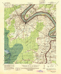
~ White Castle LA topo map, 1:62500 scale, 15 X 15 Minute, Historical, 1936, updated 1937
White Castle, Louisiana, USGS topographic map dated 1936.
Includes geographic coordinates (latitude and longitude). This topographic map is suitable for hiking, camping, and exploring, or framing it as a wall map.
Printed on-demand using high resolution imagery, on heavy weight and acid free paper, or alternatively on a variety of synthetic materials.
Topos available on paper, Waterproof, Poly, or Tyvek. Usually shipping rolled, unless combined with other folded maps in one order.
- Product Number: USGS-5594996
- Free digital map download (high-resolution, GeoPDF): White Castle, Louisiana (file size: 8 MB)
- Map Size: please refer to the dimensions of the GeoPDF map above
- Weight (paper map): ca. 55 grams
- Map Type: POD USGS Topographic Map
- Map Series: HTMC
- Map Verison: Historical
- Cell ID: 64469
- Scan ID: 335118
- Imprint Year: 1937
- Woodland Tint: Yes
- Edit Year: 1936
- Survey Year: 1936
- Datum: NAD
- Map Projection: Polyconic
- Map published by United States Army Corps of Engineers
- Map Language: English
- Scanner Resolution: 600 dpi
- Map Cell Name: White Castle
- Grid size: 15 X 15 Minute
- Date on map: 1936
- Map Scale: 1:62500
- Geographical region: Louisiana, United States
Neighboring Maps:
All neighboring USGS topo maps are available for sale online at a variety of scales.
Spatial coverage:
Topo map White Castle, Louisiana, covers the geographical area associated the following places:
- Bruly La Croix - Belle Rose - Southwood - Haaseville - Glenmore - LeBlanc - Freetown - Mount Houmas - Belle Alliance - Modeste - Star - Louisville (historical) - Blythwood - Noel - Barton - Richland - Bruly McCall - Palo Alto - Amehe (historical) - Lula - Dorcyville - Cora - Samstown - Monty - Klotzville - Augusta - Alhambra - Laurel Ridge - Miles - Carville - Philadelphia Point - Texas - Dreyfus (historical) - Geary (historical) - Soniat - Catherine - Burbank (historical) - Bruly Saint Martin - McCall - White Castle - Grand Bayou - Kessler - Tally Ho - Cannonburg - Smoke Bend - Bruns - Hohen Solms - Bayou Corne - Cedar Grove (historical) - Annadale - Geismar - Lone Star - Bayou Goula - Belle Terre - Sweet Home - Magnolia - Goldridge
- Map Area ID: AREA30.2530-91.25-91
- Northwest corner Lat/Long code: USGSNW30.25-91.25
- Northeast corner Lat/Long code: USGSNE30.25-91
- Southwest corner Lat/Long code: USGSSW30-91.25
- Southeast corner Lat/Long code: USGSSE30-91
- Northern map edge Latitude: 30.25
- Southern map edge Latitude: 30
- Western map edge Longitude: -91.25
- Eastern map edge Longitude: -91


