
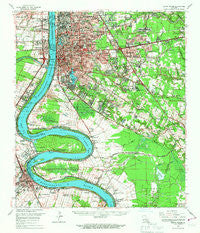
~ Baton Rouge LA topo map, 1:62500 scale, 15 X 15 Minute, Historical, 1963, updated 1967
Baton Rouge, Louisiana, USGS topographic map dated 1963.
Includes geographic coordinates (latitude and longitude). This topographic map is suitable for hiking, camping, and exploring, or framing it as a wall map.
Printed on-demand using high resolution imagery, on heavy weight and acid free paper, or alternatively on a variety of synthetic materials.
Topos available on paper, Waterproof, Poly, or Tyvek. Usually shipping rolled, unless combined with other folded maps in one order.
- Product Number: USGS-5593546
- Free digital map download (high-resolution, GeoPDF): Baton Rouge, Louisiana (file size: 10 MB)
- Map Size: please refer to the dimensions of the GeoPDF map above
- Weight (paper map): ca. 55 grams
- Map Type: POD USGS Topographic Map
- Map Series: HTMC
- Map Verison: Historical
- Cell ID: 51010
- Scan ID: 334253
- Imprint Year: 1967
- Woodland Tint: Yes
- Datum: NAD27
- Map Projection: Polyconic
- Map published by United States Geological Survey
- Map Language: English
- Scanner Resolution: 600 dpi
- Map Cell Name: Baton Rouge
- Grid size: 15 X 15 Minute
- Date on map: 1963
- Map Scale: 1:62500
- Geographical region: Louisiana, United States
Neighboring Maps:
All neighboring USGS topo maps are available for sale online at a variety of scales.
Spatial coverage:
Topo map Baton Rouge, Louisiana, covers the geographical area associated the following places:
- Wellington - West Sherwood Forest - Sherwood Garden Homes - Plantation Trace - Cinclare Landing (historical) - Red Oak - Sharlo - Westdale Heights - Kings Hill - Baton Rouge - Shenandoah Square - Sunnybrook - Broadmoor Estates - Capital Heights - Jefferson Terrace East - Tara - Standard Heights - University View - Highland Park Heights - Pollard Estates - Eliza - Videt Place - Tigerland Acres - Night Recreational Vehicle Park - Riverbend - Moss Side Place - South Dayton - Oak Forest - Jefferson Place - Highland Estates - Pine Park - Eastgate - Turnerville - McLemore Acres - Parkview Oaks - Nicholson Estates - Briar Place - Reveille - University Gardens - Beacon Hill - Perkins South - Hickory Ridge - Howell Park - Brandon Hollow - Plantation Mobile Home Park - Riffel Place - Woodland Ridge Park - Longwood Court - Torrey Pines Mobile Home Park - Southdowns - Ogden Park - Victoria Trailer Court - Woodstone Estates - Castlewood - Mayfair Park - Parkview Oaks South - Courtland Place - Hydell - The Myrtles - Northdale - Briarcliff - Southmoore - West Baton Rouge - Shenandoah Park - Sherwood Forest Estates - Howell Park Terrace - Fairwoods - Goodwood Homesites - Sherwood Oaks South - Sherwood Forest Mobile Home Park - Walnut Hill - Aubin - East Dayton - Bluebonnet Ridge - Highland Creek - Belmont - Wimbledon Estates - Shiloh - Drusilla Place - Melrose East - Melrose Place - Dayton - Concord Estates - Jefferson Terrace - Highland Community - Lynwood Village - Acadian Place - Beauregard Town - Bristol - Oxford Place - Oakbrook - Old Jefferson - Highland Hills - Iberville Terrace - Oak Hills Place - Bocage - Longwood - Evangeline Hermitage Estates - Harelson - Pecue Mobile Home Park
- Map Area ID: AREA30.530.25-91.25-91
- Northwest corner Lat/Long code: USGSNW30.5-91.25
- Northeast corner Lat/Long code: USGSNE30.5-91
- Southwest corner Lat/Long code: USGSSW30.25-91.25
- Southeast corner Lat/Long code: USGSSE30.25-91
- Northern map edge Latitude: 30.5
- Southern map edge Latitude: 30.25
- Western map edge Longitude: -91.25
- Eastern map edge Longitude: -91


