
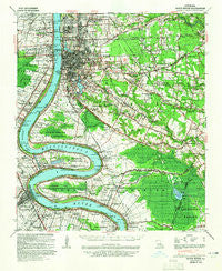
~ Baton Rouge LA topo map, 1:62500 scale, 15 X 15 Minute, Historical, 1939, updated 1965
Baton Rouge, Louisiana, USGS topographic map dated 1939.
Includes geographic coordinates (latitude and longitude). This topographic map is suitable for hiking, camping, and exploring, or framing it as a wall map.
Printed on-demand using high resolution imagery, on heavy weight and acid free paper, or alternatively on a variety of synthetic materials.
Topos available on paper, Waterproof, Poly, or Tyvek. Usually shipping rolled, unless combined with other folded maps in one order.
- Product Number: USGS-5593542
- Free digital map download (high-resolution, GeoPDF): Baton Rouge, Louisiana (file size: 10 MB)
- Map Size: please refer to the dimensions of the GeoPDF map above
- Weight (paper map): ca. 55 grams
- Map Type: POD USGS Topographic Map
- Map Series: HTMC
- Map Verison: Historical
- Cell ID: 51010
- Scan ID: 334251
- Imprint Year: 1965
- Woodland Tint: Yes
- Edit Year: 1939
- Datum: NAD27
- Map Projection: Polyconic
- Map published by United States Geological Survey
- Map published by United States Army Corps of Engineers
- Map published by United States Department of War
- Map Language: English
- Scanner Resolution: 600 dpi
- Map Cell Name: Baton Rouge
- Grid size: 15 X 15 Minute
- Date on map: 1939
- Map Scale: 1:62500
- Geographical region: Louisiana, United States
Neighboring Maps:
All neighboring USGS topo maps are available for sale online at a variety of scales.
Spatial coverage:
Topo map Baton Rouge, Louisiana, covers the geographical area associated the following places:
- Broadmoor Terrace - Sweetbriar - Belmont - Sherwood Forest Estates - Brightside Park - Tigerland Acres - South Broadmoor - Fairmont - South Dayton - Highland Road Estates - Stevendale Park - Inniswold - Barkley Place - Partridge Lane Heights - Villa Ashley - The Highlands - Oak Park - Oxford Place - Independence Place - Dayton - Ashley - Woodshire Village - McLemore Acres - North Red Oaks - Hickory Ridge - Sardine Point Settlement (historical) - Sherwood Oaks - Mayfair Park - Goodwood Homesites - Oakcrest - University Gardens - Seymourville - Dougherty Place - Bonaire - Evergreen Plantation - Cinclare - Sherwood Manor - South Highland - Lafitte Hill - Castlewood - Foreman - White Plains - Walden - Harelson - Meadow Park - Fairwoods - Belfort - Howell Park - Afton Oaks - Evangeline Hermitage Estates - Jefferson Terrace - Pioneer Park - Bristol - Moss Side Place - Country Club Estates - Cinclare Landing (historical) - Roppolo Villa - Lake Sherwood Acres - Bayou Paul - Istrouma - Wimbledon Estates - University Shadows - Bluebonnet Ridge - Stevensdale - Harwich - Silverside Heights Garden - Royal Oak - Greenwell Forest - Poplar Grove Plantation - Zeeland Place - Sherwood Forest - Plantation Trace - Soulouque - Cedarcrest Mobile Home Park - Woodlawn Estates - Prescott Place - Concord Estates - Oak Valley - Mayfair Park North - Jefferson Place - Eden Park - Myrtle Grove - Highland Estates - Anchorage - Burtville - Country Road - Darius Place - Court Street Estates Mobile Home Park - Gardere - Zee Zee Gardens - Riverside Mobile Home Park - Turnerville - Madeline Court - Willow Glen - Land O'Lakes - Ben Hur (historical) - Stevendale Heights - Beauregard Town - Perkins Place - Sherwood Meadow
- Map Area ID: AREA30.530.25-91.25-91
- Northwest corner Lat/Long code: USGSNW30.5-91.25
- Northeast corner Lat/Long code: USGSNE30.5-91
- Southwest corner Lat/Long code: USGSSW30.25-91.25
- Southeast corner Lat/Long code: USGSSE30.25-91
- Northern map edge Latitude: 30.5
- Southern map edge Latitude: 30.25
- Western map edge Longitude: -91.25
- Eastern map edge Longitude: -91


