
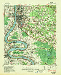
~ Baton Rouge LA topo map, 1:62500 scale, 15 X 15 Minute, Historical, 1939, updated 1947
Baton Rouge, Louisiana, USGS topographic map dated 1939.
Includes geographic coordinates (latitude and longitude). This topographic map is suitable for hiking, camping, and exploring, or framing it as a wall map.
Printed on-demand using high resolution imagery, on heavy weight and acid free paper, or alternatively on a variety of synthetic materials.
Topos available on paper, Waterproof, Poly, or Tyvek. Usually shipping rolled, unless combined with other folded maps in one order.
- Product Number: USGS-5593540
- Free digital map download (high-resolution, GeoPDF): Baton Rouge, Louisiana (file size: 10 MB)
- Map Size: please refer to the dimensions of the GeoPDF map above
- Weight (paper map): ca. 55 grams
- Map Type: POD USGS Topographic Map
- Map Series: HTMC
- Map Verison: Historical
- Cell ID: 51010
- Scan ID: 334250
- Imprint Year: 1947
- Woodland Tint: Yes
- Edit Year: 1939
- Datum: NAD
- Map Projection: Polyconic
- Map published by United States Army Corps of Engineers
- Map published by United States Army
- Map published by United States Department of War
- Map Language: English
- Scanner Resolution: 600 dpi
- Map Cell Name: Baton Rouge
- Grid size: 15 X 15 Minute
- Date on map: 1939
- Map Scale: 1:62500
- Geographical region: Louisiana, United States
Neighboring Maps:
All neighboring USGS topo maps are available for sale online at a variety of scales.
Spatial coverage:
Topo map Baton Rouge, Louisiana, covers the geographical area associated the following places:
- Royal Oak - Plaza 12 Garden Homes - Inniswold Estates - Turnerville - Centurion Place - Park Forest East - Quail Run - Camelot - Beaulieu - Village Cote - Perkins Village - Mirabeau Gardens - Old Jefferson - Iberville Terrace - Parkview Oaks - Airline Acres - Sherwood Meadow - North Sherwood Forest - Concord Park - University View - Heatherstone - Bayou Paul - South Baton Rouge - Melrose Place - Wildwood - Fairmont - Broadmoor Place - Bogan - Silverside - Plaquemine - Li Rocchi - Tara Place - University Acres - Magellan Place - Quail Ridge - Cedarcrest - Anchorage - Aubin - Essen South - Meadow Park - Woodshire Village - Oak Park - Gardere Place - Village Saint George - Ben Hur (historical) - Highland Road Estates - Highland Park Heights - Lafitte Hill - Donwood - University Shadows - Howell Park - Eliza - Country Road - Oak Hill - Bell Grove Place - Broadmoor Forest - Burden Estates - Oakcrest - Parkview East - Foreman - Cinclare Landing (historical) - Acadiana - Park Plaza - Walnut Hill - Quail Hollow - Ogden Park - Maribel Village - Kleinpeter - Afton Oaks - Highland Lakes - Delmont Place - Wooddale East - Longwood - Bristol - Pollard Estates - Nesser - Red Oak - Executive Park - Bell Fontaine - Pasadena - Pecue Mobile Home Park - Saint Gabriel - Essen - Windsor Place - Court Street Estates Mobile Home Park - Standard Heights - Greenwell Forest - B and K Mobile Park - Brousard Plaza - Castlewood - Highlandia - Highland Creek - Progress - Round Oak - The Woodlands - Longwood Court - Madeline Court - Shiloh - Shenandoah Square - Southdowns
- Map Area ID: AREA30.530.25-91.25-91
- Northwest corner Lat/Long code: USGSNW30.5-91.25
- Northeast corner Lat/Long code: USGSNE30.5-91
- Southwest corner Lat/Long code: USGSSW30.25-91.25
- Southeast corner Lat/Long code: USGSSE30.25-91
- Northern map edge Latitude: 30.5
- Southern map edge Latitude: 30.25
- Western map edge Longitude: -91.25
- Eastern map edge Longitude: -91


