
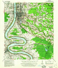
~ Baton Rouge LA topo map, 1:62500 scale, 15 X 15 Minute, Historical, 1939, updated 1960
Baton Rouge, Louisiana, USGS topographic map dated 1939.
Includes geographic coordinates (latitude and longitude). This topographic map is suitable for hiking, camping, and exploring, or framing it as a wall map.
Printed on-demand using high resolution imagery, on heavy weight and acid free paper, or alternatively on a variety of synthetic materials.
Topos available on paper, Waterproof, Poly, or Tyvek. Usually shipping rolled, unless combined with other folded maps in one order.
- Product Number: USGS-5593538
- Free digital map download (high-resolution, GeoPDF): Baton Rouge, Louisiana (file size: 10 MB)
- Map Size: please refer to the dimensions of the GeoPDF map above
- Weight (paper map): ca. 55 grams
- Map Type: POD USGS Topographic Map
- Map Series: HTMC
- Map Verison: Historical
- Cell ID: 51010
- Scan ID: 334249
- Imprint Year: 1960
- Woodland Tint: Yes
- Edit Year: 1939
- Datum: NAD
- Map Projection: Polyconic
- Map published by United States Geological Survey
- Map published by United States Army Corps of Engineers
- Map published by United States Department of War
- Map Language: English
- Scanner Resolution: 600 dpi
- Map Cell Name: Baton Rouge
- Grid size: 15 X 15 Minute
- Date on map: 1939
- Map Scale: 1:62500
- Geographical region: Louisiana, United States
Neighboring Maps:
All neighboring USGS topo maps are available for sale online at a variety of scales.
Spatial coverage:
Topo map Baton Rouge, Louisiana, covers the geographical area associated the following places:
- McGehee Place - Shiloh - Sunshine - Sharp - Briar Place - Drusilla Place - Baton Rouge - Centurion Place - Willow Glen - Arlington - Park Forest East - Bogan - Morning Glen - Perkins Place - Tara - Sable Chase - Melrose Place - Park Forest - Walnut Hill - University View - Woodland Ridge - Port Allen Landing - South Broadmoor - Goodwood - Burtville - Palm Hills - Acadiana - Bernard Terrace - Iberville Terrace - Eden Park - North Red Oaks - Belmont - Courtland Place - Meadow Lea - Highland Hills - Eliza - Southmoore - Broussard Landing - Westminster - Hillside - Lafitte Hill - South Baton Rouge - Silverside - Woodlawn Acres - Seymourville - Royal Oak - Lynwood Village - Broadmoor Forest - South Highlands - Castille - Shenandoah - Chatsworth Acres - Jefferson Terrace - Baton Rouge Terrace - Brown (historical) - Longwood - Brookhollow Glen - Essen South - Shenandoah Square - Castlewood - Torrey Pines Mobile Home Park - Kildare - Oak Hills Place - Perkins South - Bristol - Myrtle Grove - Plaquemine - Bonaire - Greenwell Forest - Westchester - Westdale Heights - Harelson - Dougherty Place - The Myrtles - Kleinert - Ashley - Stevendale Park - Delmont Place - Harwich - The Highlands - Country Club Estates - Sherwood Oaks - Southdowns - Highland Park Heights - Oakwood Forest - Airline Acres - Essen - Turnerville - West Sherwood Forest - Iberville - Allemania - Jefferson Shadows - Quail Run - Darius Place - Kings Hill - Eastland - Lakeland Terrace - Brousard Plaza - Highland Crossing - Cinclare
- Map Area ID: AREA30.530.25-91.25-91
- Northwest corner Lat/Long code: USGSNW30.5-91.25
- Northeast corner Lat/Long code: USGSNE30.5-91
- Southwest corner Lat/Long code: USGSSW30.25-91.25
- Southeast corner Lat/Long code: USGSSE30.25-91
- Northern map edge Latitude: 30.5
- Southern map edge Latitude: 30.25
- Western map edge Longitude: -91.25
- Eastern map edge Longitude: -91


