
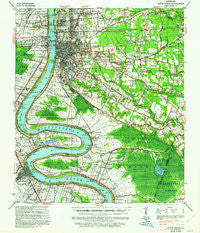
~ Baton Rouge LA topo map, 1:62500 scale, 15 X 15 Minute, Historical, 1939, updated 1962
Baton Rouge, Louisiana, USGS topographic map dated 1939.
Includes geographic coordinates (latitude and longitude). This topographic map is suitable for hiking, camping, and exploring, or framing it as a wall map.
Printed on-demand using high resolution imagery, on heavy weight and acid free paper, or alternatively on a variety of synthetic materials.
Topos available on paper, Waterproof, Poly, or Tyvek. Usually shipping rolled, unless combined with other folded maps in one order.
- Product Number: USGS-5593536
- Free digital map download (high-resolution, GeoPDF): Baton Rouge, Louisiana (file size: 9 MB)
- Map Size: please refer to the dimensions of the GeoPDF map above
- Weight (paper map): ca. 55 grams
- Map Type: POD USGS Topographic Map
- Map Series: HTMC
- Map Verison: Historical
- Cell ID: 51010
- Scan ID: 334248
- Imprint Year: 1962
- Woodland Tint: Yes
- Edit Year: 1939
- Datum: NAD
- Map Projection: Polyconic
- Map published by United States Geological Survey
- Map published by United States Army Corps of Engineers
- Map published by United States Department of War
- Map Language: English
- Scanner Resolution: 600 dpi
- Map Cell Name: Baton Rouge
- Grid size: 15 X 15 Minute
- Date on map: 1939
- Map Scale: 1:62500
- Geographical region: Louisiana, United States
Neighboring Maps:
All neighboring USGS topo maps are available for sale online at a variety of scales.
Spatial coverage:
Topo map Baton Rouge, Louisiana, covers the geographical area associated the following places:
- Highland Community - Country Road - Northdale - Wedgewood - Bocage - Sherwood Forest Mobile Home Park - Highland Gardens - Delmont Place - Kenilworth - The Highlands - Gardere Mobile Park - Sherwood Forest Estates - Broussard Landing - Park Plaza - Woodcrest - Centurion Place - Oxford Place - Allemania - Evangeline Hermitage Estates - Parkview Oaks - Videt Place - Rushmore - Hickory Ridge - Bristol - Laurel Lea - Park Forest - Howell Park - Monterrey Park - Wellington - Broadmoor Estates - Istrouma - University View - Lynwood Village - College Drive Heights - Stevendale Estates - Ashley - Oakbrook - Ogden Park - Windsor Place - Westdale Terrace - Lake Forest Park - Morrisonville - Belfair - Westchester - College Hills - Dent Terrace - Silverside Heights Garden - Briarcliff - Howell Park Terrace - Green Back Forest - The Hideaway - Ben Hur (historical) - Magnolia Ridge - Arlington - Lukeville - Saint Gerald Park - Dayton - Briar Place - Inniswold Estates - South Sherwood Forest - Inniswold - Night Recreational Vehicle Park - Dougherty Place - Cedarcrest - Greenville - McLemore Acres - Forest Oaks - Nesser - Shamrock Gardens - Lynn Place - Hydell - The Myrtles - Port Allen - Sherwood Meadow - Jefferson Place - Pine Park - Pioneer Park - Broadmoor Forest - Torrey Pines Mobile Home Park - Executive Park - Woodland Ridge - Bird - Foreman - Kleinert - Glenmore - Pecue Mobile Home Park - Kingsbridge - Essen Plaza - Broadmoor Plaza - Briarwood Estates - Sherwood Manor - Cinclare - Concord Estates - Magnolia Terrace - Lafitte Hill - Smiley Heights - University Shadows - Randolph Heights - The Woodlands - Fox Run
- Map Area ID: AREA30.530.25-91.25-91
- Northwest corner Lat/Long code: USGSNW30.5-91.25
- Northeast corner Lat/Long code: USGSNE30.5-91
- Southwest corner Lat/Long code: USGSSW30.25-91.25
- Southeast corner Lat/Long code: USGSSE30.25-91
- Northern map edge Latitude: 30.5
- Southern map edge Latitude: 30.25
- Western map edge Longitude: -91.25
- Eastern map edge Longitude: -91


