
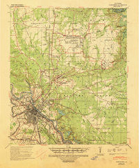
~ Alexandria LA topo map, 1:62500 scale, 15 X 15 Minute, Historical, 1941, updated 1944
Alexandria, Louisiana, USGS topographic map dated 1941.
Includes geographic coordinates (latitude and longitude). This topographic map is suitable for hiking, camping, and exploring, or framing it as a wall map.
Printed on-demand using high resolution imagery, on heavy weight and acid free paper, or alternatively on a variety of synthetic materials.
Topos available on paper, Waterproof, Poly, or Tyvek. Usually shipping rolled, unless combined with other folded maps in one order.
- Product Number: USGS-5593450
- Free digital map download (high-resolution, GeoPDF): Alexandria, Louisiana (file size: 8 MB)
- Map Size: please refer to the dimensions of the GeoPDF map above
- Weight (paper map): ca. 55 grams
- Map Type: POD USGS Topographic Map
- Map Series: HTMC
- Map Verison: Historical
- Cell ID: 50416
- Scan ID: 334196
- Imprint Year: 1944
- Woodland Tint: Yes
- Edit Year: 1941
- Datum: NAD
- Map Projection: Polyconic
- Map published by United States Army Corps of Engineers
- Map published by United States Army
- Map published by United States Department of War
- Map Language: English
- Scanner Resolution: 600 dpi
- Map Cell Name: Alexandria
- Grid size: 15 X 15 Minute
- Date on map: 1941
- Map Scale: 1:62500
- Geographical region: Louisiana, United States
Neighboring Maps:
All neighboring USGS topo maps are available for sale online at a variety of scales.
Spatial coverage:
Topo map Alexandria, Louisiana, covers the geographical area associated the following places:
- Simms - Anandale - Green Gables - Garnett (historical) - Wardville - Pineville Junction - Bob - Fort Randolph - Libuse - Kingsville - Alexandria Junction - Pineville - Samtown - Smithville - Thomas (historical) - Nugent - Tioga - Oak Park Mobile Homes Court - Paradise - Kent - Sieps - Prospect - Kolin - Shady Oaks - Timber Trails - Lee Heights - Ball - Fort Buhlow - Alexandria - Moller - Stay
- Map Area ID: AREA31.531.25-92.5-92.25
- Northwest corner Lat/Long code: USGSNW31.5-92.5
- Northeast corner Lat/Long code: USGSNE31.5-92.25
- Southwest corner Lat/Long code: USGSSW31.25-92.5
- Southeast corner Lat/Long code: USGSSE31.25-92.25
- Northern map edge Latitude: 31.5
- Southern map edge Latitude: 31.25
- Western map edge Longitude: -92.5
- Eastern map edge Longitude: -92.25


