
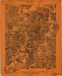
~ Dunmor KY topo map, 1:48000 scale, 15 X 15 Minute, Historical, 1911
Dunmor, Kentucky, USGS topographic map dated 1911.
Includes geographic coordinates (latitude and longitude). This topographic map is suitable for hiking, camping, and exploring, or framing it as a wall map.
Printed on-demand using high resolution imagery, on heavy weight and acid free paper, or alternatively on a variety of synthetic materials.
Topos available on paper, Waterproof, Poly, or Tyvek. Usually shipping rolled, unless combined with other folded maps in one order.
- Product Number: USGS-5678538
- Free digital map download (high-resolution, GeoPDF): Dunmor, Kentucky (file size: 13 MB)
- Map Size: please refer to the dimensions of the GeoPDF map above
- Weight (paper map): ca. 55 grams
- Map Type: POD USGS Topographic Map
- Map Series: HTMC
- Map Verison: Historical
- Cell ID: 72724
- Scan ID: 804166
- Survey Year: 1911
- Datum: Unstated
- Map Projection: Unstated
- Map published by United States Geological Survey
- Keywords: Overedge; Nonstandard Press Run
- Map Language: English
- Scanner Resolution: 508 dpi
- Map Cell Name: Dunmar
- Grid size: 15 X 15 Minute
- Date on map: 1911
- Map Scale: 1:48000
- Geographical region: Kentucky, United States
Neighboring Maps:
All neighboring USGS topo maps are available for sale online at a variety of scales.
Spatial coverage:
Topo map Dunmor, Kentucky, covers the geographical area associated the following places:
- Davenport Landing - Mount Zion (historical) - Townsville (historical) - Beechland - Provo - Hope (historical) - Dunmor - McPhersons (historical) - Quality - Rochester - Boston - Hickory Stand (historical) - Hollow Bill - Diamond Springs - South Hill - Dunbar - Gupton Grove (historical) - Anderson - Sand Spring - Pogue (historical) - Wolf Lick - Harper Crossroads - Penrod - Mining City - Harreldsville - Toy Spring (historical) - Huntsville - Riverside (historical) - Gus - Knightsburg - Silver City - Forgytown (historical) - Pleasant Hill - Forest Oak (historical) - Rock Springs (historical) - Skilesville - Turnertown - Stringtown (historical) - Pauline (historical) - McCoytown (historical) - Forest Grove (historical) - Ennis - Mud River Union (historical)
- Map Area ID: AREA37.2537-87-86.75
- Northwest corner Lat/Long code: USGSNW37.25-87
- Northeast corner Lat/Long code: USGSNE37.25-86.75
- Southwest corner Lat/Long code: USGSSW37-87
- Southeast corner Lat/Long code: USGSSE37-86.75
- Northern map edge Latitude: 37.25
- Southern map edge Latitude: 37
- Western map edge Longitude: -87
- Eastern map edge Longitude: -86.75


