
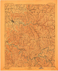
~ Beattyville KY topo map, 1:125000 scale, 30 X 30 Minute, Historical, 1892, updated 1912
Beattyville, Kentucky, USGS topographic map dated 1892.
Includes geographic coordinates (latitude and longitude). This topographic map is suitable for hiking, camping, and exploring, or framing it as a wall map.
Printed on-demand using high resolution imagery, on heavy weight and acid free paper, or alternatively on a variety of synthetic materials.
Topos available on paper, Waterproof, Poly, or Tyvek. Usually shipping rolled, unless combined with other folded maps in one order.
- Product Number: USGS-5294868
- Free digital map download (high-resolution, GeoPDF): Beattyville, Kentucky (file size: 6 MB)
- Map Size: please refer to the dimensions of the GeoPDF map above
- Weight (paper map): ca. 55 grams
- Map Type: POD USGS Topographic Map
- Map Series: HTMC
- Map Verison: Historical
- Cell ID: 64967
- Scan ID: 804131
- Imprint Year: 1912
- Survey Year: 1890
- Datum: Unstated
- Map Projection: Unstated
- Map published by United States Geological Survey
- Map Language: English
- Scanner Resolution: 508 dpi
- Map Cell Name: Beattyville
- Grid size: 30 X 30 Minute
- Date on map: 1892
- Map Scale: 1:125000
- Geographical region: Kentucky, United States
Neighboring Maps:
All neighboring USGS topo maps are available for sale online at a variety of scales.
Spatial coverage:
Topo map Beattyville, Kentucky, covers the geographical area associated the following places:
- Old Landing - Jeffersonville - Ravenna - Rothwell - Millers Creek - Coburn (historical) - Piggville (historical) - Tallega - Monica - East Fork Slate (historical) - El Park (historical) - Heidelberg - Fillmore - Trimble (historical) - Fincastle - Lucky Stop - Belle Point - Cow Creek (historical) - South Fork (historical) - Cat Creek (historical) - Wind Cave - Hatton Creek (historical) - Macedonia (historical) - Copebranch - Pinnacle - Frenchburg - Texola - Old Lombard (historical) - Campton - Drip Rock - Camp Branch (historical) - Means - Tipton Ridge - Bowen - Ida May - Upper Cane (historical) - Lone - Lower Buffalo - Willow Shoals - Stacey Neighborhood (historical) - Primrose - Clay City - McCausey Ridge (historical) - Delvinta - Saint Helens - Watson (historical) - High Falls - Dog Trot (historical) - Crystal - Black Creek (historical) - Fortner (historical) - Spaas Creek (historical) - Leighton - Judy (historical) - Fixer - Crow (historical) - Valeria - Myers Fork (historical) - Hemlock Lodge (historical) - Buck Creek (historical) - Cressmont - Westbend - South Irvine - Scranton - Denniston - Pilot - Ballard (historical) - West Denniston (historical) - Campton Road (historical) - Happy Top (historical) - Lynch Town (historical) - Cane Springs (historical) - Furnace - Pryse - Greenbriar (historical) - Wilder (historical) - Kimbrell - Foxtown - Calloway Creek (historical) - Leeco - Hawkins Branch (historical) - North Irvine - Zoe - Stump (historical) - Stanton - Grannie - South Fork (historical) - New Providence (historical) - Lakes - Reeves (historical) - Rebelsville (historical) - Salem (historical) - Hathaway Creek (historical) - Glencairn - Torrent - Congleton - Lone Oak (historical) - Vada - Mariba - Mary
- Map Area ID: AREA3837.5-84-83.5
- Northwest corner Lat/Long code: USGSNW38-84
- Northeast corner Lat/Long code: USGSNE38-83.5
- Southwest corner Lat/Long code: USGSSW37.5-84
- Southeast corner Lat/Long code: USGSSE37.5-83.5
- Northern map edge Latitude: 38
- Southern map edge Latitude: 37.5
- Western map edge Longitude: -84
- Eastern map edge Longitude: -83.5


