
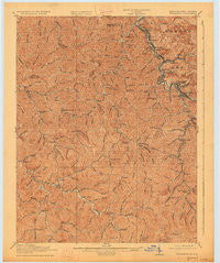
~ Williamson KY topo map, 1:62500 scale, 15 X 15 Minute, Historical, 1918, updated 1927
Williamson, Kentucky, USGS topographic map dated 1918.
Includes geographic coordinates (latitude and longitude). This topographic map is suitable for hiking, camping, and exploring, or framing it as a wall map.
Printed on-demand using high resolution imagery, on heavy weight and acid free paper, or alternatively on a variety of synthetic materials.
Topos available on paper, Waterproof, Poly, or Tyvek. Usually shipping rolled, unless combined with other folded maps in one order.
- Product Number: USGS-5294798
- Free digital map download (high-resolution, GeoPDF): Williamson, Kentucky (file size: 8 MB)
- Map Size: please refer to the dimensions of the GeoPDF map above
- Weight (paper map): ca. 55 grams
- Map Type: POD USGS Topographic Map
- Map Series: HTMC
- Map Verison: Historical
- Cell ID: 64558
- Scan ID: 804343
- Imprint Year: 1927
- Survey Year: 1915
- Datum: NAD
- Map Projection: Polyconic
- Map published by United States Geological Survey
- Map Language: English
- Scanner Resolution: 508 dpi
- Map Cell Name: Williamson
- Grid size: 15 X 15 Minute
- Date on map: 1918
- Map Scale: 1:62500
- Geographical region: Kentucky, United States
Neighboring Maps:
All neighboring USGS topo maps are available for sale online at a variety of scales.
Spatial coverage:
Topo map Williamson, Kentucky, covers the geographical area associated the following places:
- Leckieville - Goodman - Mouth of Long Fork (historical) - Bevins Branch (historical) - Slatter Branch (historical) - Chattaroy - Pigeon Roost (historical) - Morcoal (historical) - Sidney - Pinsonfork - Upper Dick (historical) - Zebulon - Piso - West Williamson - Sydney (historical) - Borderland - Hatfield - Laura - Fairview - Huddy - Sharondale - Blackburn Bottom - New Camp - Road Fork (historical) - Grassy Branch (historical) - East Williamson - Nolan - Belfry - Stone - Varney - Hatfield - Goody - Rural - South Williamson - Meta - Forest Hills - Tom Ray (historical) - Canada - Turkey Creek - Williamson - Heenon - Right Fork of Meathouse (historical) - Toler - Old Sydney (historical) - Elkins Fork (historical) - Victoria Court - Upper Turkey (historical) - McVeigh - McAndrews - Williamson Terrace
- Map Area ID: AREA37.7537.5-82.5-82.25
- Northwest corner Lat/Long code: USGSNW37.75-82.5
- Northeast corner Lat/Long code: USGSNE37.75-82.25
- Southwest corner Lat/Long code: USGSSW37.5-82.5
- Southeast corner Lat/Long code: USGSSE37.5-82.25
- Northern map edge Latitude: 37.75
- Southern map edge Latitude: 37.5
- Western map edge Longitude: -82.5
- Eastern map edge Longitude: -82.25


