
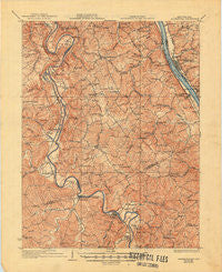
~ Alexandria KY topo map, 1:62500 scale, 15 X 15 Minute, Historical, 1936, updated 1950
Alexandria, Kentucky, USGS topographic map dated 1936.
Includes geographic coordinates (latitude and longitude). This topographic map is suitable for hiking, camping, and exploring, or framing it as a wall map.
Printed on-demand using high resolution imagery, on heavy weight and acid free paper, or alternatively on a variety of synthetic materials.
Topos available on paper, Waterproof, Poly, or Tyvek. Usually shipping rolled, unless combined with other folded maps in one order.
- Product Number: USGS-5294262
- Free digital map download (high-resolution, GeoPDF): Alexandria, Kentucky (file size: 7 MB)
- Map Size: please refer to the dimensions of the GeoPDF map above
- Weight (paper map): ca. 55 grams
- Map Type: POD USGS Topographic Map
- Map Series: HTMC
- Map Verison: Historical
- Cell ID: 50414
- Scan ID: 803287
- Imprint Year: 1950
- Survey Year: 1929
- Datum: NAD
- Map Projection: Polyconic
- Map published by United States Geological Survey
- Map Language: English
- Scanner Resolution: 508 dpi
- Map Cell Name: Alexandria
- Grid size: 15 X 15 Minute
- Date on map: 1936
- Map Scale: 1:62500
- Geographical region: Kentucky, United States
Neighboring Maps:
All neighboring USGS topo maps are available for sale online at a variety of scales.
Spatial coverage:
Topo map Alexandria, Kentucky, covers the geographical area associated the following places:
- Poplar Thicket (historical) - Fisher Ridge (historical) - Claryville - Aspen Grove - Blairsville - Oneonta - Flower Town (historical) - Fairlane - Gubser Mill - Wilmington (historical) - Hawthorne - Greenwood - Peach Grove - Clermontville - Kohler - Visalia - Meridian - Beagle - Flagg Spring - Persimmon Grove - Fairview - Boston - Morning View - Alexandria - California - Big Bend (historical) - Abbott (historical) - Tarvan (historical) - Oakland (historical) - White Villa - Taylor Mill - Ryland - Springlake - DeMossville - Clay Ridge (historical) - Pye - Reis (historical) - Butler - New Richmond - Maple Valley (historical) - Pleasant Ridge (historical) - Twelvemile (historical) - Hopeful (historical) - Springdale - Alexander - California Crossing (historical) - Lamb - Dry Ridge (historical) - Grant - Plum Creek (historical) - Carthage - Latonia Lakes - Ryland Heights - Caldwell - Kenton - Grants Lick - Fourmile (historical) - Mount Auburn
- Map Area ID: AREA3938.75-84.5-84.25
- Northwest corner Lat/Long code: USGSNW39-84.5
- Northeast corner Lat/Long code: USGSNE39-84.25
- Southwest corner Lat/Long code: USGSSW38.75-84.5
- Southeast corner Lat/Long code: USGSSE38.75-84.25
- Northern map edge Latitude: 39
- Southern map edge Latitude: 38.75
- Western map edge Longitude: -84.5
- Eastern map edge Longitude: -84.25


