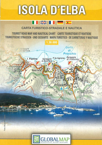
Isola dElba : carta turistico-stradale e nautica
Elba on a detailed map from Litografia Artistica Cartografica, with an indexed street plan of Portoferraio. The map offers a nice balance between clarity of road detail for exploring the island by car, tourist information, and a topographic base with overprint for waymarked hiking routes.
Road network, including local country roads and tracks, is easy to see against the relief shading. A very wide range of symbols provide tourist information, including campsites and camper parks, beaches and scuba diving sites, numerous other sport and recreational facilities, archaeological sites, museums and monuments, etc.
For hikers map has contours at 20m intervals and an overprint highlighting waymarked walking trails, indicating their official numbering. For GPS users the map has a 1km UTM grid.
A large inset shows a street plan of Portoferraio with an index listing both streets and places of interest, including the museum devoted to Elba’s most famous prisoner. On the reve
- Product Number: LAC_TU_ELBA_17
- Reference Product Number: 2033002M
- ISBN: 9788833030050
- Date of Publication: 6/1/2017
- Folded Size: 6.69 inches high by 4.33 inches wide
- Unfolded (flat) Size: 38.58 inches high by 26.38 inches wide
- Map format: Folded
- Map type: Trade Maps - Tourist
- Geographical region: Italy