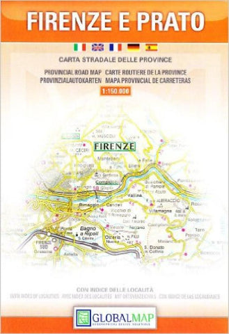
Firenze e Prato : carta stradale della provincia
Florence and Prato Provinces at 1:150,000 in a series of handy size provincial road maps from Litografia Artistica Cartografica (LAC) with more minor local roads and country tracks than can be found on most regional maps from other publishers. This title is now available in a digitally produced edition.
LAC’s provincial series is gradually being changed to a new style of digitally derived cartography, so presentation of adjoining titles may vary. All the maps have hill shading to represent the general relief with spot heights for selected peaks, and show a few more local roads and rough tracks than the other road map series. Intermediate road distances are indicated. Regional, provincial and communal borders are marked, and railways, funiculars, airports, sea ferry links and campsites are shown. The legend is in Italian only.
The new, digitally produced editions are indexed and have improved, more finely drawn cartography: the hill-shading is less bold, motorway service
- Product Number: LAC_PR_FIRENZE_10
- Reference Product Number: 2048492M
- ISBN: 9788879143417
- Date of Publication: 6/1/2010
- Folded Size: 7.09 inches high by 5.12 inches wide
- Unfolded (flat) Size: 25.59 inches high by 28.35 inches wide
- Map format: Folded
- Map type: Trade Maps - Road
- Geographical region: Italy