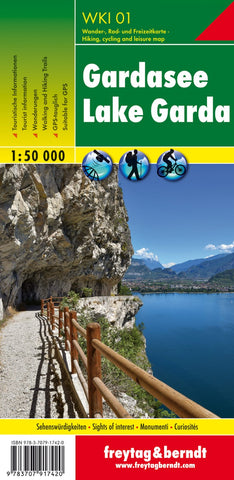
Lake Garda, hiking map 1:50,000
One of the titles in a series of contoured outdoor leisure maps, extending F&B’s extensive coverage of Austria to the neighbouring regions and other popular hiking areas of Germany. The maps have contours at 100-metre intervals in the mountainous areas, and 50 metres elsewhere, shading and graphic relief. An overprint highlights hiking paths, cycling routes and, on most of the titles, ski routes. The maps also show youth hostels, campsites, mountain huts and refuges. Margin ticks show latitude and longitude in steps of 5. Most titles also give GPS waypoints, as indicated in the individual descriptions. Map legend includes English.
Several of the titles come with a separate booklet, in German only, containing information on places of interest, brief descriptions of selected hiking trails, addresses of various accommodation facilities, etc.
- Product Number: FB_WKI_50_01_18
- Reference Product Number: - None -
- ISBN: 9783707917420
- Date of Publication: 12/17/2018
- Folded Size: 8.06 inches high by 3.93 inches wide
- Unfolded (flat) Size: 8.06 inches high by 3.93 inches wide
- Map format: Folded
- Map type: Trade Maps - Hiking
- Geographical region: Italy