
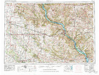
~ Dubuque IA topo map, 1:250000 scale, 1 X 2 Degree, Historical, 1959, updated 1982
Dubuque, Iowa, USGS topographic map dated 1959.
Includes geographic coordinates (latitude and longitude). This topographic map is suitable for hiking, camping, and exploring, or framing it as a wall map.
Printed on-demand using high resolution imagery, on heavy weight and acid free paper, or alternatively on a variety of synthetic materials.
Topos available on paper, Waterproof, Poly, or Tyvek. Usually shipping rolled, unless combined with other folded maps in one order.
- Product Number: USGS-5283841
- Free digital map download (high-resolution, GeoPDF): Dubuque, Iowa (file size: 19 MB)
- Map Size: please refer to the dimensions of the GeoPDF map above
- Weight (paper map): ca. 55 grams
- Map Type: POD USGS Topographic Map
- Map Series: HTMC
- Map Verison: Historical
- Cell ID: 68757
- Scan ID: 174553
- Imprint Year: 1982
- Woodland Tint: Yes
- Photo Revision Year: 1981
- Aerial Photo Year: 1978
- Edit Year: 1981
- Datum: NAD27
- Map Projection: Transverse Mercator
- Map published by United States Geological Survey
- Map published by: Military, Other
- Map Language: English
- Scanner Resolution: 600 dpi
- Map Cell Name: Dubuque
- Grid size: 1 X 2 Degree
- Date on map: 1959
- Map Scale: 1:250000
- Geographical region: Iowa, United States
Neighboring Maps:
All neighboring USGS topo maps are available for sale online at a variety of scales.
Spatial coverage:
Topo map Dubuque, Iowa, covers the geographical area associated the following places:
- Prairieburg - Waubeek - Patch Grove - Snefs - Masonville - Shullsburg - Donnan - Massey - Paris - Massbach - Bali Hai Estates Mobile Home Park - Albany - Maynard - Council Hill - Etna - Squaw Creek Village - Winston - Jonesdale - Miles - Cheney - Cottage Hill - Five Points - Bremen - Worthington - Almoral - Jamestown - Westgate - King - Monticello - Morley - Mederville - Spragueville - Riverside - Carlton Mobile Home Court - Monmouth - Millbrig (historical) - Shellsburg - Jackson - Tennyson - Amber - Dubuque - Downers Grove - O'Neill - Griffiths Mobile Home Park - Benton City (historical) - Hiawatha Oak Brook Court - Fair Play - Flora Fountain - Avon - McCartney - Mineral Point - Lakeview Mobile Home Court - Alice - Blackhawk - Pleasant Valley - Nashville - Lore - Van Buren - Ceres - Blanding - Onslow - Shawondasse - Edgewood - Clayton - Diamond Grove - Louisburg - Dyersville - Argand - Oneida - White Oak - Monti - Baldwin - Center Grove - Dutchtown - Buena Vista - Elizabeth - Northend Mobile Home Park - Aurora - Osterdock - Cedar Rapids - Cottonville - South Garry Owen - Waupeton - Thomasville - Elkport - Scotch Grove - Orchard Lane Mobile Home Court - Rockville - Center Junction - Rutledge - Volga - Hurricane - Linn Junction - Paralta - West Union - Cobb - South Switch Junction - Cass - Spencers Grove - Elkader
- Map Area ID: AREA4342-92-90
- Northwest corner Lat/Long code: USGSNW43-92
- Northeast corner Lat/Long code: USGSNE43-90
- Southwest corner Lat/Long code: USGSSW42-92
- Southeast corner Lat/Long code: USGSSE42-90
- Northern map edge Latitude: 43
- Southern map edge Latitude: 42
- Western map edge Longitude: -92
- Eastern map edge Longitude: -90


