
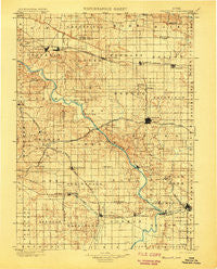
~ Stanwood IA topo map, 1:125000 scale, 30 X 30 Minute, Historical, 1901
Stanwood, Iowa, USGS topographic map dated 1901.
Includes geographic coordinates (latitude and longitude). This topographic map is suitable for hiking, camping, and exploring, or framing it as a wall map.
Printed on-demand using high resolution imagery, on heavy weight and acid free paper, or alternatively on a variety of synthetic materials.
Topos available on paper, Waterproof, Poly, or Tyvek. Usually shipping rolled, unless combined with other folded maps in one order.
- Product Number: USGS-5283783
- Free digital map download (high-resolution, GeoPDF): Stanwood, Iowa (file size: 8 MB)
- Map Size: please refer to the dimensions of the GeoPDF map above
- Weight (paper map): ca. 55 grams
- Map Type: POD USGS Topographic Map
- Map Series: HTMC
- Map Verison: Historical
- Cell ID: 66686
- Scan ID: 175581
- Survey Year: 1898
- Datum: Unstated
- Map Projection: Unstated
- Map published by United States Geological Survey
- Keywords: Nonstandard Press Run
- Map Language: English
- Scanner Resolution: 600 dpi
- Map Cell Name: Stanwood
- Grid size: 30 X 30 Minute
- Date on map: 1901
- Map Scale: 1:125000
- Geographical region: Iowa, United States
Neighboring Maps:
All neighboring USGS topo maps are available for sale online at a variety of scales.
Spatial coverage:
Topo map Stanwood, Iowa, covers the geographical area associated the following places:
- Lime City - West Branch - Clarence - Stanwood - Wilton - Colonial Estates Mobile Home Park - Breckenridge Estates - West Branch Mobile Home Village - Mount Vernon - Downey - Newport - Morse - Modern Manor Mobile Home Park - Mechanicsville - Springdale - Atalissa - West Liberty - Sutliff - Parkhurst (historical) - Ayresville - Wald - Olin - Oasis - Elmira - Centerdale - Midway (historical) - Vernon Heights Mobile Home Park - Summit - Tipton - Rochester - Moscow - Cedar Valley - South Towne Park - Sunrise Mobile Home Village - Buchanan - Lisbon - Cedar Bluff - Plato - Solon - Tipton Mobile Home Park - Graham (historical) - Bon-Aire Mobile Home Lodge
- Map Area ID: AREA4241.5-91.5-91
- Northwest corner Lat/Long code: USGSNW42-91.5
- Northeast corner Lat/Long code: USGSNE42-91
- Southwest corner Lat/Long code: USGSSW41.5-91.5
- Southeast corner Lat/Long code: USGSSE41.5-91
- Northern map edge Latitude: 42
- Southern map edge Latitude: 41.5
- Western map edge Longitude: -91.5
- Eastern map edge Longitude: -91


