
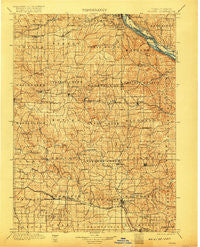
~ Peosta IA topo map, 1:125000 scale, 30 X 30 Minute, Historical, 1901, updated 1917
Peosta, Iowa, USGS topographic map dated 1901.
Includes geographic coordinates (latitude and longitude). This topographic map is suitable for hiking, camping, and exploring, or framing it as a wall map.
Printed on-demand using high resolution imagery, on heavy weight and acid free paper, or alternatively on a variety of synthetic materials.
Topos available on paper, Waterproof, Poly, or Tyvek. Usually shipping rolled, unless combined with other folded maps in one order.
- Product Number: USGS-5283777
- Free digital map download (high-resolution, GeoPDF): Peosta, Iowa (file size: 9 MB)
- Map Size: please refer to the dimensions of the GeoPDF map above
- Weight (paper map): ca. 55 grams
- Map Type: POD USGS Topographic Map
- Map Series: HTMC
- Map Verison: Historical
- Cell ID: 66314
- Scan ID: 175360
- Imprint Year: 1917
- Survey Year: 1896
- Datum: Unstated
- Map Projection: Unstated
- Map published by United States Geological Survey
- Keywords: Nonstandard Press Run
- Map Language: English
- Scanner Resolution: 600 dpi
- Map Cell Name: Peosta
- Grid size: 30 X 30 Minute
- Date on map: 1901
- Map Scale: 1:125000
- Geographical region: Iowa, United States
Neighboring Maps:
All neighboring USGS topo maps are available for sale online at a variety of scales.
Spatial coverage:
Topo map Peosta, Iowa, covers the geographical area associated the following places:
- Garry Owen - Ozark - Kidder - East Canton - Ironhills - Fulton - East Iron Hills - Canton - Otter Creek - Centralia - Delmar - Washington Mills - Temple Hill - East Dubuque - McGargels Ford - Buckhorn - La Motte - Table Mound Mobile Home Park - Cathedral Square - Wilkins - Key West - Julien - South Switch Junction - King - Twin T Mobile Home Park - Menominee - Zwingle - Ballyclough - Peosta - Bennettsville - Baldwin - Crab Town - West Iron Hills - Clay Mills - Lattnerville - Emeline - Saint Donatus - Lost Canyon Mobile Home Park - Hurstville - Center Grove - Monmouth - Cottonville - Shawondasse - South Garry Owen - Epworth - Graf - Millrock - Ozark (historical) - Andrew - Pleasant Grove - Rockdale - Cattese - Fillmore - Massey - Bernard - Riggs - Maquoketa - Nashville - Bridgeport - Ace Mobile Home Park
- Map Area ID: AREA42.542-91-90.5
- Northwest corner Lat/Long code: USGSNW42.5-91
- Northeast corner Lat/Long code: USGSNE42.5-90.5
- Southwest corner Lat/Long code: USGSSW42-91
- Southeast corner Lat/Long code: USGSSE42-90.5
- Northern map edge Latitude: 42.5
- Southern map edge Latitude: 42
- Western map edge Longitude: -91
- Eastern map edge Longitude: -90.5


