
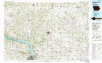
~ Dubuque North IA topo map, 1:100000 scale, 30 X 60 Minute, Historical, 1984, updated 1989
Dubuque North, Iowa, USGS topographic map dated 1984.
Includes geographic coordinates (latitude and longitude). This topographic map is suitable for hiking, camping, and exploring, or framing it as a wall map.
Printed on-demand using high resolution imagery, on heavy weight and acid free paper, or alternatively on a variety of synthetic materials.
Topos available on paper, Waterproof, Poly, or Tyvek. Usually shipping rolled, unless combined with other folded maps in one order.
- Product Number: USGS-5283661
- Free digital map download (high-resolution, GeoPDF): Dubuque North, Iowa (file size: 22 MB)
- Map Size: please refer to the dimensions of the GeoPDF map above
- Weight (paper map): ca. 55 grams
- Map Type: POD USGS Topographic Map
- Map Series: HTMC
- Map Verison: Historical
- Cell ID: 67439
- Scan ID: 174543
- Imprint Year: 1989
- Woodland Tint: Yes
- Photo Inspection Year: 1986
- Aerial Photo Year: 1983
- Edit Year: 1984
- Datum: NAD27
- Map Projection: Universal Transverse Mercator
- Map published by United States Geological Survey
- Map Language: English
- Scanner Resolution: 600 dpi
- Map Cell Name: Dubuque North
- Grid size: 30 X 60 Minute
- Date on map: 1984
- Map Scale: 1:100000
- Geographical region: Iowa, United States
Neighboring Maps:
All neighboring USGS topo maps are available for sale online at a variety of scales.
Spatial coverage:
Topo map Dubuque North, Iowa, covers the geographical area associated the following places:
- Buena Vista - Annaton - Five Points - Holy Cross - Frith Spur - Waldwick - Linden - Edmore - Lore - Meekers Grove - Platteville - Old Balltown - Gratiot - Rutledge - Asbury - Cuba City - Preston - Waupeton - Sandy Hook - Cornelia - Darlington - Union - Beetown - Livingston - Eagle Point - Diamond Grove - Mineral Point - Stitzer - Durango - Fair Play - Mount Hope - North Buena Vista - Kieler - Slateford - Hurricane - Jenkinsville - Patch Grove - Van Buren - Sageville - Burton - Sinsinawa - Sherrill - Lore Mobile Home Park - Truman - Cottage Hill - British Hollow - Bigpatch - Tennyson - Apple River - Flora Fountain - Knapp Mobile Home Park - Benton - Rewey - Granada Mobile Home Park - Balltown - Cassville - Calamine - Bloomington - Dickeyville - Ipswich - O'Neill - Lancaster - Shady Dell - Maple Lane Trailer Court - Mount Ida - Georgetown - McCartney - Mifflin - Arthur - Rose - Belmont - Montfort - Potosi - Jamestown - Cameron - Rockville - Northend Mobile Home Park - Lead Mine - Rickardsville - Budd - Shullsburg - Saint Rose - Avon - East Rickardsville - North Andover - Twin Springs - Ellenboro - Prairie Corners - Five Points - Strawbridge - Louisburg - Red Rock - Dubuque - Fennimore - Dodgeville - New Diggings - Leslie - Dunbarton - White Oak - Etna
- Map Area ID: AREA4342.5-91-90
- Northwest corner Lat/Long code: USGSNW43-91
- Northeast corner Lat/Long code: USGSNE43-90
- Southwest corner Lat/Long code: USGSSW42.5-91
- Southeast corner Lat/Long code: USGSSE42.5-90
- Northern map edge Latitude: 43
- Southern map edge Latitude: 42.5
- Western map edge Longitude: -91
- Eastern map edge Longitude: -90


