
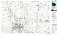
~ Des Moines IA topo map, 1:100000 scale, 30 X 60 Minute, Historical, 1984, updated 1985
Des Moines, Iowa, USGS topographic map dated 1984.
Includes geographic coordinates (latitude and longitude). This topographic map is suitable for hiking, camping, and exploring, or framing it as a wall map.
Printed on-demand using high resolution imagery, on heavy weight and acid free paper, or alternatively on a variety of synthetic materials.
Topos available on paper, Waterproof, Poly, or Tyvek. Usually shipping rolled, unless combined with other folded maps in one order.
- Product Number: USGS-5283657
- Free digital map download (high-resolution, GeoPDF): Des Moines, Iowa (file size: 16 MB)
- Map Size: please refer to the dimensions of the GeoPDF map above
- Weight (paper map): ca. 55 grams
- Map Type: POD USGS Topographic Map
- Map Series: HTMC
- Map Verison: Historical
- Cell ID: 67412
- Scan ID: 174509
- Imprint Year: 1985
- Woodland Tint: Yes
- Aerial Photo Year: 1983
- Edit Year: 1984
- Datum: NAD27
- Map Projection: Universal Transverse Mercator
- Planimetric: Yes
- Map published by United States Geological Survey
- Map Language: English
- Scanner Resolution: 600 dpi
- Map Cell Name: Des Moines
- Grid size: 30 X 60 Minute
- Date on map: 1984
- Map Scale: 1:100000
- Geographical region: Iowa, United States
Neighboring Maps:
All neighboring USGS topo maps are available for sale online at a variety of scales.
Spatial coverage:
Topo map Des Moines, Iowa, covers the geographical area associated the following places:
- Easton Place - Hastie - Monroe - Park View Village Mobile Home Park - Rider - Andrews - Newton - Woodward - Pine Grove Mobile Home Park - Pleasant Hill - Runnells - Ingersoll (historical) - Urbandale - Swanwood - Sheldahl - Madrid - Goddard - Iowa Center - Polk City Junction - Valeria - South Ridge Estates - Maxwell - Melbourne - Gibbsville - Rocklyn Mobile Home - Enterprise - Berwick - Altoona - Western Village Mobile Home Park - Herrold - Santiago - Van Meter - Adelphi - Waukee - Carlisle - Levey - Granger - Ankeny - Bondurant - Xenia - Radio City Mobile Home Park - Polk City - Saylor - Crocker - Loring - Capitol Heights - Rising Sun - Millman - Coal Siding (historical) - Ashawa - Midvale - Quilhart (historical) - Mel-Ray Mobile Home Park - Crestwood - Edenville - Mitchellville - Malta - Country Living Mobile Home Park - East Des Moines - Paradise Mobile Home Park - Sunrise Mobile Home Community - Green Castle - State Center Junction - Cambridge - Pleasant Valley Mobile Home Park - The Meadows - Sunny-Brook Mobile Home Park - West Des Moines - Van Cleve - Stover Heights Community - Norwoodville - Luther - Commerce - Dallas Center - Grandview Village Mobile Home Park - Baxter - Prairie City - Des Moines - Alleman - Rhodes - Vandalia - Oakwood Heights Mobile Home Park - Wilson (historical) - Van - Shipley - Blue Bird Mobile Park - Corydon (historical) - Ortonville - Ivy - Oralabor - Robison-Whitaker Acres - Rolling Hills Mobile Home Park - Lakewood - Farrar - Mingo - Carney - Oakwood Station (historical) - Orilla - Woodland Hills - Midwest Country Estates
- Map Area ID: AREA4241.5-94-93
- Northwest corner Lat/Long code: USGSNW42-94
- Northeast corner Lat/Long code: USGSNE42-93
- Southwest corner Lat/Long code: USGSSW41.5-94
- Southeast corner Lat/Long code: USGSSE41.5-93
- Northern map edge Latitude: 42
- Southern map edge Latitude: 41.5
- Western map edge Longitude: -94
- Eastern map edge Longitude: -93


