
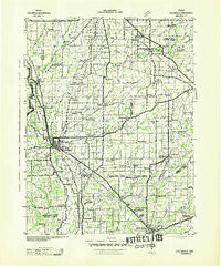
~ Columbus IN topo map, 1:125000 scale, 30 X 30 Minute, Historical, 1942
Columbus, Indiana, USGS topographic map dated 1942.
Includes geographic coordinates (latitude and longitude). This topographic map is suitable for hiking, camping, and exploring, or framing it as a wall map.
Printed on-demand using high resolution imagery, on heavy weight and acid free paper, or alternatively on a variety of synthetic materials.
Topos available on paper, Waterproof, Poly, or Tyvek. Usually shipping rolled, unless combined with other folded maps in one order.
- Product Number: USGS-5289212
- Free digital map download (high-resolution, GeoPDF): Columbus, Indiana (file size: 6 MB)
- Map Size: please refer to the dimensions of the GeoPDF map above
- Weight (paper map): ca. 55 grams
- Map Type: POD USGS Topographic Map
- Map Series: HTMC
- Map Verison: Historical
- Cell ID: 65247
- Scan ID: 159663
- Woodland Tint: Yes
- Aerial Photo Year: 1941
- Datum: NAD27
- Map Projection: Polyconic
- Advance: Yes
- Map published by United States Army Corps of Engineers
- Map published by United States Department of War
- Map Language: English
- Scanner Resolution: 600 dpi
- Map Cell Name: Columbus
- Grid size: 30 X 30 Minute
- Date on map: 1942
- Map Scale: 1:125000
- Geographical region: Indiana, United States
Neighboring Maps:
All neighboring USGS topo maps are available for sale online at a variety of scales.
Spatial coverage:
Topo map Columbus, Indiana, covers the geographical area associated the following places:
- Pleasure Valley - Everroad Park - Letts Corner - Waldron - Riverview Acres - Tannersville - Adams - Peters Switch - Petersville - Brewersville - Saint Paul - Neff Corner - Newbern - Marietta - Pinhook - East Columbus - Queensville - Sleepy Hollow - Jonesville - Flat Rock Park - Nortonburg - Old Saint Louis - Lowell - Westport - North Columbus - Hartsville - Norristown - Gaynorsville - Bengal - Downeyville - Forest Park - Oakdale - Mapleton Corner - Forest Hill - Little Acre - Craig - Butlerville - Mount Auburn - Harper - Milford - Reddington - Grammer - Waynesburg - Rosstown - Burnsville - Wilson Corner - North Gate - Cuba - Bobtown - Saint Omer - Middletown - Fenns - Clifford - Country Squire Lakes - North Vernon - Garden City - Pleasant View Village - Elizabethtown - Jewell Village - Taylorsville - Rugby - Geneva - Scipio - Hope - Burney - Columbus - Parkside - Horace - Moscow - Sardinia - Flat Rock - Camp Flat Rock - Prescott - Alert - Edinburgh - Smithland - Northcliff - North Park - Walesboro - Ewington - Letts - Germantown - Bethel Village - Lewis Creek - Saint Louis Crossing - Corn Brook - Morven - Harris City - Azalia - Waynesville
- Map Area ID: AREA39.539-86-85.5
- Northwest corner Lat/Long code: USGSNW39.5-86
- Northeast corner Lat/Long code: USGSNE39.5-85.5
- Southwest corner Lat/Long code: USGSSW39-86
- Southeast corner Lat/Long code: USGSSE39-85.5
- Northern map edge Latitude: 39.5
- Southern map edge Latitude: 39
- Western map edge Longitude: -86
- Eastern map edge Longitude: -85.5


