
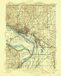
~ Alton IL topo map, 1:62500 scale, 15 X 15 Minute, Historical, 1934, updated 1946
Alton, Illinois, USGS topographic map dated 1934.
Includes geographic coordinates (latitude and longitude). This topographic map is suitable for hiking, camping, and exploring, or framing it as a wall map.
Printed on-demand using high resolution imagery, on heavy weight and acid free paper, or alternatively on a variety of synthetic materials.
Topos available on paper, Waterproof, Poly, or Tyvek. Usually shipping rolled, unless combined with other folded maps in one order.
- Product Number: USGS-5531189
- Free digital map download (high-resolution, GeoPDF): Alton, Illinois (file size: 10 MB)
- Map Size: please refer to the dimensions of the GeoPDF map above
- Weight (paper map): ca. 55 grams
- Map Type: POD USGS Topographic Map
- Map Series: HTMC
- Map Verison: Historical
- Cell ID: 50472
- Scan ID: 309200
- Imprint Year: 1946
- Survey Year: 1927
- Datum: NAD
- Map Projection: Polyconic
- Map published by United States Geological Survey
- Map Language: English
- Scanner Resolution: 600 dpi
- Map Cell Name: Alton
- Grid size: 15 X 15 Minute
- Date on map: 1934
- Map Scale: 1:62500
- Geographical region: Illinois, United States
Neighboring Maps:
All neighboring USGS topo maps are available for sale online at a variety of scales.
Spatial coverage:
Topo map Alton, Illinois, covers the geographical area associated the following places:
- Wanda - Wood River - Spanish Lake - Dorsey - Kendall Hill - Mitchell - Quatoga Bluff - Ivy Heights - Fairmont - Milton - West Alton - Meadowbrook - Fort Bellefontaine - Oldenburg - Cottage Hills - Upper Alton - Alton - Godfrey - North Alton - Glasgow Village - Castle Point - Rosewood Heights - South Roxana - Lakeview - Forest Homes - Roxana - Fosterburg - Brooks - Hartford - Saint Thomas - East Alton - Alandale - Rosedale - Belmont Village - Bethalto - Woods - Poag - Altamont - Oakwood Heights - Cedar Park - Southmoor - Sloan - Kic-ka-poo Village (historical) - Moro - Melville - Larimore
- Map Area ID: AREA3938.75-90.25-90
- Northwest corner Lat/Long code: USGSNW39-90.25
- Northeast corner Lat/Long code: USGSNE39-90
- Southwest corner Lat/Long code: USGSSW38.75-90.25
- Southeast corner Lat/Long code: USGSSE38.75-90
- Northern map edge Latitude: 39
- Southern map edge Latitude: 38.75
- Western map edge Longitude: -90.25
- Eastern map edge Longitude: -90


