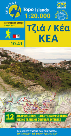
Tzia (Kea) (1:27 000) Hiking Map
Hiking map of Kea (Tzia) island in a scale of 1:27.000
A mountainous island, rich vegetation with abundant spring waters and beautiful cobbled paths, Kea is ideal for hiking. All the more so that most of the paths are well signposted and lead to magnificent beaches.
For the visitor who wants to get acquainted with the countryside of Kea, 12 routes are suggested where most of the natural and historical wealth of the island is concentrated. It is a network of approximately 80 km of trails, many of which are cobbled paths. Their marking with the characteristic red / white plates is partially complete. The creation of the network is an implementation of the program Routes of Cultural Interest in the Cyclades implemented by the Department of Culture of the South Aegean Region. The routes combine natural landscapes and invisible inland monuments with descent to the most beautiful beaches.
- Product Number: ANA_TZIA_HIKE_19
- Reference Product Number: - None -
- ISBN: 9789608195820
- Date of Publication: 1/1/2019
- Folded Size: 9.45 inches high by 4.5 inches wide
- Unfolded (flat) Size: 26.6 inches high by 19.5 inches wide
- Map format: Folded
- Map type: Trade Maps - Hiking
- Geographical region: Greece