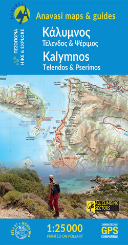
Kalimnos (1:25 000) Hiking Map
Hiking map of Kalimnos island in a scale of 1:25.000
Kalimnos (also written Kalymnos or Calymnos) is an island of the Dodecanese archipelago, and climbing destination of the Mediterranean with more 2000 climbing routes. Kalimnos hiking map is waterproof and tear-resistant. The map shows all hiking trails and rock climbing sites.
It features contours lines every 20m with hill shading. The map indicates dirt roads in poor condition, with distances marked on many local routes, plus locations of car parks and petrol stations. Also marked are stops of the local bus service. Foktpaths distinguish between wide and well defined or narrow and/or poorly defined routes. Symbols highlight various facilities and places of interest. All place names are in both Greek and Latin alphabets. The map has a 1km UTM grid plus latitude/longitude margin ticks and crosshairs at 1’.
On the reverse the whole island is shown on a slightly simplified map at the same scale, designed to highligh
- Product Number: ANA_KALIMNOS_HIKE_20
- Reference Product Number: - None -
- ISBN: 9789608195943
- Date of Publication: 1/1/2020
- Folded Size: 9.2 inches high by 4.89 inches wide
- Unfolded (flat) Size: 38.9 inches high by 26.6 inches wide
- Map format: Folded
- Map type: Trade Maps - Hiking
- Geographical region: Greece